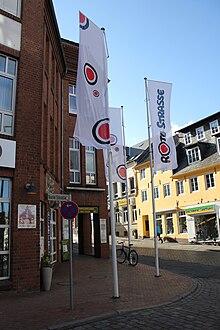
Rote Strasse (Flensburg)
The Rote Straße ( Danish : Rødegade or Rudegade in Low German Rode Straat ) is a street in the southern old town of Flensburg , in the area of the Flensburg city center . It leads from Südermarkt (Søndertorv) to Neumarkt (Nytorv) , from where it is not far to the district of Rude , where the name of the street comes from.
location
Originally it was the only arterial road going south. It begins in the southwest corner of Südermarkt, where it meets Friesische Strasse (Frisergade) , which together with Angelburger Strasse (Angelbogade), which leads to the east, forms one of the oldest east-west connections in this region. The Holm , the central axis of the city, meets the square from the north . Behind the Neumarkt, already outside the original urban development, but located on the city field, it splits into the arterial roads to Husum and Schleswig . In the Middle Ages, between these was the Rude, a wood from which both the city district that exists there today and the Rote Straße take their names. Even then, the Franciscan monastery bordered the street.
history
As an access road from the south, which also borders on the city's most important market square, the Rote Straße has been primarily a street of inns for centuries, especially on its west side. On the east side there used to be the poor house of the Nikolaikirchspiel and, since the 16th century, the city's Latin school . The Red Gate marked the southern entrance and exit of the city until 1872. To the south of it there were already three water mills on the open city field in the course of the Scherrebek flowing by here. Behind it, the Neumarkt was built in the 19th century, where Rote Straße splits into Schleswiger (Slesviggade) and Husumer Straße (Husumgade) .
With the relocation of through traffic in the 1920s, Rote Straße was degraded to a side street, which, however, retained its character as a commercial and restaurant street. However, there have been massive interventions since the 1950s. In the course of the demolition of the Töpferstrasse (Pottemagergade) , which flows into the east, house number 21 was lost in 1954, one of the most valuable and oldest half-timbered houses in the city. The city claimed to want to keep the individual parts of the four hundred year old house for later reconstruction. In 1964 the new town hall was built west of the street . The construction of a parking garage meant the demolition of a large part of the east line of the street. Although the preserved part of Rote Strasse remained a busy shopping street, the backyards in particular fell into disrepair.
Todays situation
At the end of the 1980s, Rote Straße was also affected by the increasing renovation of the old town. The courtyards on the west side were revitalized with restaurants and small shops, the car park front on the east side was built in front of the old building fabric, which also houses shops and restaurants. The large number of art galleries is striking. The street became a pedestrian zone and is now one of the most popular business and nightlife streets in the city, especially among tourists. The southern part got its historical guidance back, but offers a complete contrast to the old town character of the northern half of the street with large new buildings from the 2000s and the large parking lot that extends from the street to the town hall. The Red Gate, which was once there, is used as today's symbol for the street.
Individual evidence
- ↑ Paul Selk (Ed.): Flensburg anecdotes . 1st edition. Husum Druck- und Verlagsgesellschaft mbH u. Co. KG, Husum 1978, ISBN 3-88042-072-6 , 113. Torf levern, p. 77 (with the collaboration of Renate Delfs ).
- ↑ Active pensioners, torsdagsholdet (Ed.): Flensborgs gadenavne . Flensburg 1995, p. 21 .
- ↑ Active pensioners, torsdagsholdet (Ed.): Flensborgs gadenavne . Flensburg 1995, p. 18 .
- ↑ a b City wall and city gates. Reading and workbook on the history of Flensburg for home and general education .. from the University of Flensburg ( Memento of the original from March 4, 2016 in the Internet Archive ) Info: The archive link was inserted automatically and has not yet been checked. Please check the original and archive link according to the instructions and then remove this notice. (PDF; 1.8 MB), page 13
- ↑ Active pensioners, torsdagsholdet (Ed.): Flensborgs gadenavne . Flensburg 1995, p. 12 .
- ↑ Active pensioners, torsdagsholdet (Ed.): Flensborgs gadenavne . Flensburg 1995, p. 9 .
- ↑ Active pensioners, torsdagsholdet (Ed.): Flensborgs gadenavne . Flensburg 1995, p. 14 .
- ↑ Active pensioners, torsdagsholdet (Ed.): Flensborgs gadenavne . Flensburg 1995, p. 22 .
- ^ Writings of the Society for Flensburg City History (ed.): Flensburg in history and present . Flensburg 1972, page 413
literature
- Flensburg - history of a border town. Edited by Society for Flensburg City History. Flensburg 1966.
Web links
Coordinates: 54 ° 46 '54.7 " N , 9 ° 26' 8.8" E


