Red Fountain (Wittislingen)
| Red fountain | |
|---|---|
 Red fountain |
|
| location | |
| Country or region | District of Dillingen an der Donau , Swabia ( Bavaria ) |
| Coordinates | 48 ° 37 ′ 35 ″ N , 10 ° 26 ′ 5 ″ E |
| geology | |
| Source type | Karst spring |
| rock | White Jura |
| Hydrology | |
| River system | Danube |
| Receiving waters | Klosterweihergraben → Klosterbach → Danube → Black Sea |
Coordinates: 48 ° 37 ′ 35 ″ N , 10 ° 26 ′ 5 ″ E
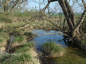
The Red Fountain is a karst spring designated as a natural monument near Wittislingen in Swabia (Bavaria).
description
The red fountain is located south of the Maria Medingen monastery , directly on the St 2033. It is a boggy spring with red-brown shimmering water. The color comes from iron solutions and karst clay. The spring water arises from the mass limestone layer of the Upper Jura . The Klosterweihergraben , which rises there, flows over the Klosterbach to the Danube .
The source has been identified as a valuable geotope by the Bavarian State Office for the Environment (geotope number: 773Q001).
See also
Individual evidence
- ↑ Bavarian State Office for the Environment, Geotope T source outlet "Roter Brunnen" S from Mödingen Monastery (accessed on October 9, 2017).
Web links
Commons : Roter Brunnen - Collection of pictures, videos and audio files