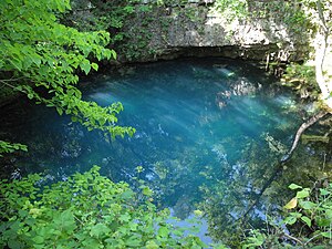
Round Spring
| Round Spring | |||
|---|---|---|---|
 Round Spring |
|||
| location | |||
| Country or region | Shannon County , Missouri ( United States ) | ||
| Coordinates | 37 ° 16 ′ 58 " N , 91 ° 24 ′ 28" W. | ||
|
|||
| geology | |||
| Mountains | Ozark Mountains | ||
| Source type | Karst spring | ||
| Exit type | Source pot | ||
| Hydrology | |||
| River system | Mississippi River | ||
| Receiving waters | Current River → Black River → White River → Mississippi River → Gulf of Mexico | ||
| Bulk | 1100 l / s | ||
| depth | 17 m | ||
Coordinates: 37 ° 16 '58 " N , 91 ° 24' 28" W.
The Round Spring is a karst spring in the state of Missouri in the United States .
description
Round Spring is located in Shannon County in the Ozark Mountains , in the settlement of Round Spring . The blue shimmering, about 17 m deep, circular spring pot is surrounded by rocks and pours an average of 1100 l / s. The stream that rises there flows into the Current River .
See also
Web links
Commons : Round Spring - collection of images, videos and audio files
Individual evidence
- ↑ Google Earth
