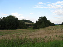
Runigerodt
Runigerodt (also called Runigerode or Rüningerode ) is a desert in the district of Göttingen . It is located about 2.5 km west of Herzberg am Harz and about 1 km southeast of Hörden am Harz . Runigerodt was first mentioned in a document in 952. The time of the desertification is not known.
According to the results of a site survey, Runigerodt was presumably a two-lined row village on the Herzberg-Hörden route. One of three ponds that used to exist is still used today for fish farming. 1.4 km southeast of Runigerodt is the desert of Koyhagen , 2.3 km northeast of the Hage desert and 1.4 km to the north is the former Kalkburg .
literature
- Erhard Kühlhorn: The medieval desolations in southern Lower Saxony Volume 3. O – Z, Publishing House for Regional History, Bielefeld 1995, ISBN 3-89534-133-9 , pp. 237–244.
- Uwe Ohainski and Jürgen Udolph: The place names of the district of Osterode , Verlag für Regionalgeschichte, Bielefeld 2000, ISBN 3-89534-370-6 , p. 143
- Dietrich Denecke , Göttinger geographische Abhandlungen, Heft 54, 1969, The medieval and early modern network of roads and the facilities based on it, together with the settlements and economic centers in the area between Solling and Harz , supplement: overview map, Verlag Erich Goltze KG, Göttingen 1969
- Klaus Gehmlich: Field names in the district of Osterode am Harz , Volume 4, M-Sp, Papierflieger Verlag, Clausthal-Zellerfeld 2012, ISBN 978-3-86948-203-3 , p. 145
Coordinates: 51 ° 39 ′ 41.8 ″ N , 10 ° 18 ′ 4 ″ E
