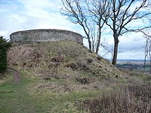
Ruperra Moth
Ruperra Motte (also Craig Ruperra Motte , Castell Breiniol or Castell y Ddraenen ) is a castle stable in Caerphilly in Wales .
history
Probably after the Norman conquest of Morgannwg at the end of the 11th century, a castle was built on the site on the remains of an Iron Age hill fort . Like the Castell Coch further east, it was supposed to protect the Norman rule of Cardiff against the Welsh rule in the Glamorgan highlands . However, the castle is not mentioned in any written source and is probably abandoned again in the 12th century. The Welsh rulers in the Glamorgan highlands, such as Senghenydd and Meisgyn , remained under loose Anglo-Norman sovereignty before they were finally conquered by Richard de Clare and Gilbert de Clare in the middle of the 13th century .
In the 18th century, the castle hill was integrated into the park of the nearby Ruperra Castle . Before 1764, a two-storey summer house on a square floor plan was built on the summit of the Motte, which was used until the beginning of the 20th century. Since the Ruperra mansion had been neglected since the 1930s and was destroyed by fire in 1941, the park became overgrown. The summer house fell into disrepair and the castle hill was overgrown with cherry laurel , rhododendron and other shrubs. From 2001 to 2006, the overgrown castle hill was exposed again by the Ruperra Conservation Trust , which had acquired the site. The castle hill and the hill fort are protected as Scheduled Monument .
investment
The Burgstall is located at the western end of the elongated hill fort, which extends on the up to 182 m high Coed Craig Ridge north of the Rhymney Valley . At the highest point of the ridge is the moth of the former castle. The castle hill has a diameter of about 32 m at the foot and about 12 m at the top and is still about 6 m high. It is surrounded by a moat, which is well preserved, especially on the north and west sides. There are no remains of the medieval buildings or the 18th century summer house. In contrast, the spiral-shaped path with a boundary wall from the 18th century that leads to the top of the castle hill has been preserved. The hill fort over 200 m long has hardly been explored. It is surrounded in the northwest by a double moat and otherwise by a simple moat. There is no ditch in the southeast, where the terrain slopes steeply.
literature
- Royal Commission on the Ancient and Historical Monuments of Wales: An Inventory of the Ancient Monuments in Glamorgan , Vol. III - Part I: The early castles. RCAHMW, 1991, ISBN 0-11-300035-9 , p. 328
Web links
Individual evidence
- ^ Royal Commission on the Ancient and Historical Monuments of Wales: An Inventory of the Ancient Monuments in Glamorgan , Vol. III - Part I: The early castles. RCAHMW, 1991, ISBN 0-11-300035-9 , p. 59
Coordinates: 51 ° 34'25.6 " N , 3 ° 7'21.3" W.

