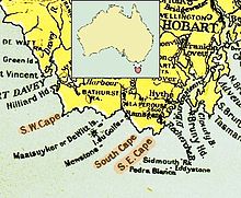
Southeast Cape
The southeast cape (Engl. South East Cape ) is the most southern point of Tasmania and with it the southernmost point of the Australian common and Tasmanian mainland.
Environment and accessibility
The Southeast Cape is located on a rocky, uninhabited peninsula in the administrative area of the Huon Valley municipality , which encompasses the entire southern coast of Tasmania. The cape is the most easterly point of a largely west-south-west-east-north-east coastline in the south of Tasmania, the westernmost point of which is the South West Cape, about 65 kilometers away . Beyond the two capes, the coastline turns to the northeast or northwest. Immediately to the west of the Southeastern Cape is the South Cape Bay , named after the South Cape , which - about ten kilometers as the crow flies from the Southeast Cape - borders its western end. A little further to the west, about 14 kilometers from the Southeast Cape, extends the eastern border of the Southwest National Park , the largest Australian national park.
Next place is Cockle Creek , the approximately 8.5 kilometers in a straight line to the northeast of the Cape in the research Bay ( Recherche Bay is located) and the southern point of Tasmania is accessible by road. A hiking trail leads from Cockle Creek to the Southeast Cape. Advanced canoeists can also paddle to the cape along the coast, which is considered to be relatively dangerous.
"Southernmost Point of Australia" and "Ocean Frontier"
The cape is often referred to as the “southernmost point of Australia”. However, this only applies to mainland Australia and Tasmania. Several islands that belong to Australian territory are more south than the Southeast Cape. These include several Tasmanian islands close to the mainland: About 45 kilometers to the west of the cape are the Maatsuyker Islands (with the Needle Rocks immediately to the southwest ), some of which extend further south than the cape, as well as the rocky island of Mewstone , which is about 11 kilometers further south than the Southeast Cape. In the east of the Southeastern Cape, a small group of rock islands rises above the water, of which Pedra Branca (coordinates: 43 ° 51'36 "S, 146 ° 58'28" E) is almost 24 kilometers further south than the Southeast Cape. On the other hand, there are the Australian islands that are far away from the mainland: The southernmost island of Australia is Macquarie Island (coordinates: 54 ° 30 'S, 158 ° 57' E), which is not only considerably further to the east, but also 1,236 Kilometers further to the south than the Southeast Cape; Macquarie Island belongs to the same Tasmanian community as the Southeast Cape ( Huon Valley ). In addition, Australia claims part of the Antarctic (see Territorial claims in the Antarctic ).
The Southeastern Cape is also sometimes viewed as an imaginary border point between the Indian Ocean and the Pacific in southern Australia. For example, the times for covering the distance between the South African Cape of Good Hope and the Australian Southeast Cape are sometimes measured as the record times for crossing the Indian Ocean .
Individual evidence
- ^ Bathurst Harbor and Maatsuyker Island , on a private website about sea kayaking tours around Tasmania (accessed April 1, 2007)
- ↑ RTW Sailing Record 2004 - Week 4 ( Memento of the original from November 17, 2006 in the Internet Archive ) Info: The archive link has been inserted automatically and has not yet been checked. Please check the original and archive link according to the instructions and then remove this notice. on the website of regatta sailor and adventurer Steve Fossett (accessed April 1, 2007)
Web links
- Map of the area around the Southeast Cape
- Photos of the cape on beta.zooomr.com and www.view.com.au
- Extensions of the continent of Australia (English)
Coordinates: 43 ° 38 ′ 40 ″ S , 146 ° 49 ′ 30 ″ E


