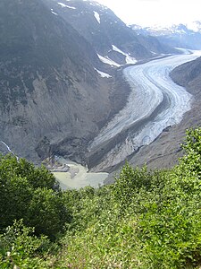
Salmon Glacier (Coast Mountains)
| Salmon Glacier | ||
|---|---|---|
|
Salmon glacier tongue |
||
| location | British Columbia ( Canada ) | |
| Mountains | Boundary Ranges ( Coast Mountains ) | |
| Type | Valley glacier | |
| length | 18 km | |
| Exposure | south | |
| Altitude range | 1580 m - 450 m | |
| width | ⌀ 1.3 km | |
| Coordinates | 56 ° 9 ′ N , 130 ° 4 ′ W | |
|
|
||
| drainage | Salmon River → Portland Canal | |
| particularities | Glacier Edge Summit Lake | |
The Salmon Glacier ( salmon English for " salmon ") is located in the Canadian province of British Columbia .
The Salmon Glacier has its nutrient area at an altitude of about 1580 m in the Boundary Ranges , a part of the Coast Mountains , not far from the border with the Alaska Panhandle . The glacier initially flows 12 km to the east, before turning south and after another 6 km ends at an altitude of 450 m . The glacier edge lake Summit Lake is located on the northern edge of the glacier. The runoff of the Boundary Glacier in Alaska used to reach the tongue of the Salmon Glacier. However, this has withdrawn in recent decades, so that the runoff now flows directly into the Salmon River , which drains the Salmon Glacier to the Portland Canal . In the upper area, the mean width of the Salmon Glacier is 1.3 km.
Web links
- Salmon Glacier . In: BC Geographical Names (English)

