Samanala Dam
| Samanala Dam | |||||||
|---|---|---|---|---|---|---|---|
| The Samanalawewa Dam | |||||||
|
|||||||
|
|
|||||||
| Coordinates | 6 ° 40 ′ 45 " N , 80 ° 47 ′ 56" E | ||||||
| Data on the structure | |||||||
| Lock type: | dam | ||||||
| Construction time: | - 1992 | ||||||
| Height of the barrier structure : | 100 m | ||||||
| Building volume: | 4.5 million m³ | ||||||
| Crown length: | 530 m | ||||||
| Slope slope on the air side : | 1: 1.8 | ||||||
| Slope slope on the water side : | 1: 2 | ||||||
| Power plant output: | 120 MW | ||||||
| Data on the reservoir | |||||||
| Altitude (at congestion destination ) | 460 m above sea level | ||||||
| Reservoir length | 8 kilometers | ||||||
| Storage space | 218 million m³ | ||||||
| Total storage space : | 278 million m³ | ||||||
| Catchment area | 342 or 372 km² (contradicting information) | ||||||
| Design flood : | 3600 m³ / s | ||||||
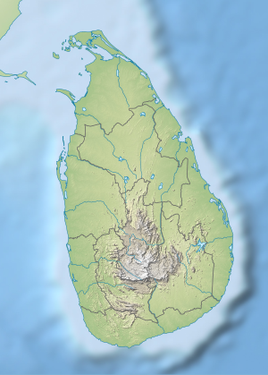
The Samanala Dam is the second largest dam in Sri Lanka after the Mahaweli Dam . It is located 160 km southeast of the capital Colombo and is used to generate electricity . Another dam (Uda Walawe) lies below on the river Walawe .
additional data
- Type of construction: stone embankment dam with inner seal made of earth
- Average discharge: 17.8 m³ / s
- Average annual discharge: 598 million m³ / a
- measured peak discharge: 719 m³ / s
In the magazine World Rivers Review (IV / 1992) a case of damage is reported when the dam was dammed in 1992. The dam was leaking and had to be laboriously repaired.
See also
Web links
- Impact of Samanala Wewa Dam on the Regional Economy of Sri Lanka (PDF file, 3772 kB)
- Panoramio photo

