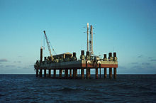
San Marco platform
Coordinates: 2 ° 56 ′ 17 ″ S , 40 ° 12 ′ 44 ″ E
The San Marco Platform ( San Marco Equatorial Range - SMER, Centro Spaziale Luigi Broglio ), or San Marco for short , is an Italian rocket launch site off the coast of Kenya for launching solid fuel rockets .
Origin of name
The name is derived from a research program at the University of Rome ( Centro Ricerche Aerospaziali - CRA ), which was formed from three components:
- High altitude exploration flights from Wallops Island and the equatorial platform
- An experimental San Marco 1 satellite launched from Wallops Island on December 15, 1964
- Satellite launches from the equatorial platform - first flight with San Marco 2 on April 26, 1967
history
Between 1964 and 1988, 18 sounding rockets and nine Scout launch vehicles were launched. For example, the X-ray satellite Uhuru ( Swahili for "freedom") was brought into orbit by the San Marco platform in 1970 with a scout rocket . On February 16, 1980, some sounding rockets were launched from this platform to observe a total solar eclipse .
Although no use was known since 1988, in particular due to the cessation of Scout production, the launch site was named Start-1 in launch plans for Russian solid rocket rockets or the European Vega program , as the platforms were approved until 2014.
Technical details
The launch facilities consisted of two former oil platforms (Santa Rita and San Marco) and two supply vessels, which are anchored at a water depth of around 20 meters. The next place on the coast is Malindi . The proximity to the equator is advantageous for equatorial or near-equatorial satellite orbits, because less fuel is required than at launch sites further away from the equator due to the higher rotational speed of the earth, but especially due to smaller orbit correction maneuvers.
Tracking station
In the Malindi, a satellite tracking station with various satellite dishes is operated directly on the coast. ESA has been operating an automatic 2-meter tracking antenna for X-band (MAL-X) there under the umbrella of ASI since 2015, which was used to launch LISA Pathfinder (LPF). The station in Malindi supports tracking of spacecraft and satellites in orbits near the equator. 2 ° 59 ′ 45.5 ″ S , 40 ° 11 ′ 39.5 ″ E
See also
Web links
- NASA: History of San Marco (PDF, 72 pages, 7.5 MB, English)
- NASA: History of the Italian San Marco Equatorial Mobile Range (PDF, 152 pages, 25 MB, English)
- San Marco in the Encyclopedia Astronautica (English)
Individual evidence
- ↑ Stars and Space , digitized version of the University of Michigan from March 19, 2010, Volume 38, Page 529. Verlag Bibliographisches Institut, 1999: “In addition, the journey at Sea Launch begins exactly on the equator, so that the earth's rotation can be used to the maximum, if a geostationary orbit is desired ”( limited preview in Google Book search, limited preview in Google Book search).

