
Sankenbach waterfalls
| Sankenbach waterfalls | ||
|---|---|---|
 Sankenbach Falls |
||
| Coordinates | 48 ° 29 '7.16 " N , 8 ° 19' 59.82" E | |
|
||
| place | Baiersbronn municipality , Freudenstadt district , Northern Black Forest , Baden-Württemberg , Germany | |
| height | 50 m falling edge : 750 m impact zone : 700 m |
|
| width | 2 m | |
| Number of fall levels | 4th | |
| Mean flow rate (MQ) | 3 l / s | |
| Falling watercourse | Sankenbach | |
| Estuarine waters | Sankenbach → Forbach → Murg | |

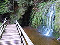
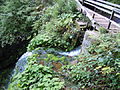
The Sankenbach waterfalls are located southwest of Baiersbronn in the Black Forest . The Sankenbach falls in several stages more than 40 m over the Karwand of the Sankenbachkessel. The main case is formed by the Eck'schen horizon of the Lower Buntsandstein . Below the waterfall , on the floor of the Kars, lies the Sankenbachsee, which was once almost silted up but has been restored by damming .
Because of the catchment area of only 0.65 square kilometers, hardly 3 l / s of water flow over the fall on an annual average. From a footbridge above the main step, however, the inflowing water in the small stilling basin of the first drop step above can be dammed up using a wooden slide; After opening the slide, the accumulated water then falls down for a while in an intensified gush. Below the main case, there are two lower case levels.
The Sankenbacher waterfalls and their surroundings are designated as 4.8 hectares of extensive natural monument .
- Stowage device
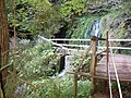
Bridge with lever to operate the stowage device
Upper case with water basin
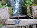
Top view of the closed slide
Damming device and edge of the lower main case

Access from below


See also
Web links
Individual evidence
- ↑ Thomas Huth, Baldur Junker: Geotourist map of Baden-Württemberg - Black Forest and surroundings - explanations. Freiburg i. Br. 2004, ISBN 3-00-014219-3 , p. 245
- ↑ Profile of the extensive natural monument in the LUBW's list of protected areas