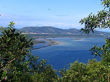
Santa Catarina (island)
The island of Santa Catarina is part of the municipality of Florianópolis and is located in the Atlantic Ocean on the central part of the coast of the state of Santa Catarina in southern Brazil , about 27 ° south of the equator and 48 ° west latitude. The north-south extension is about 54 km, the island is up to 18 km wide and has an area of 87,405 hectares.
The center of the city of Florianópolis is located in the west with a bridge connection to the mainland. Various districts are spread over the island:
- inside Carvoeira , Córrego Grande , Itacorubi , Pantanal , Parque São Jorge , Santa Monica and Trindade (with the University of UFSC ),
- in the northwest Santo Antônio de Lisboa , Cacupé , Sambaqui , Barra do Sambaqui , Daniela and Rio Vermelho .
- In the north are the seaside resorts of Ingleses , Canasvieiras and Jurerê , as well as Ratones , Vargem Grande and Vargem Pequena ,
- in the east by the lagoon or the sea Barra da Lagoa , Lagoa da Conceição , Rio Tavares and Campeche ,
- in the southeast Morro das Pedras and Armação do Pântano do Sul ,
- in the south Pântano do Sul , Costa de Dentro , Costa de Cima , Caieira da Barra do Sul and Ribeirão da Ilha .
Santa Catarina is the largest of an archipelago of over 20 islands, the largest are Anhatomirim , Araçatuba or Fortaleza , Aranhas , Campeche , Cardos , Carvão , Francês , Três Irmãs , Laranjeiras , Largo , Maria Francisca , Moleques do Norte , Moleques Pequenos , Moleques do Sul , Ratones , Vinhas and Xavier .
Three bridges connect the island to the mainland. These are the Colombo-Salles , the Pedro-Ivo-Campos and the Hercílio-Luz bridges . They span the 500 meter wide and 28 meter deep Estreito Strait , which is also the name of a district on the mainland.
climate
The climate is subtropical and humid with average temperatures of 26 ° C to 30 ° C in summer and 10 ° C to 22 ° C in winter. Due to the proximity to the sea, the average humidity is 80%. The rainy seasons fall in spring and autumn.
geography
The highest point is the hill of Ribeirão da Ilha at 532 m. Several mountain ranges stretch from north to south. There are two lagoons, the Lagoa da Conceição in the east with salt water and the freshwater lake Lagoa do Peri in the southeast, a remote smaller one is the Lagoinha do Leste . Geomorphologically, the island belongs to the Serra do Mar and Serra Geral coastal chains with occasional granite inclusions .
Web links
Footnotes
Coordinates: 27 ° 33 ′ S , 48 ° 29 ′ W

