Santa Rita (Aragua)
| Santa Rita | ||
|---|---|---|
|
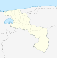
Coordinates: 10 ° 12 ′ N , 67 ° 33 ′ W Santa Rita on the map of Aragua
|
||
| Basic data | ||
| Country | Venezuela | |
| State | Aragua | |
| Residents | 134,233 | |
| - in the metropolitan area | approx 1,300,000 | |
| City insignia | ||
| Detailed data | ||
| surface | 23.8 | |
| height | 428 m | |
| Post Code | 2101-2104 | |
| Time zone | UTC -4: 30 | |
| City Presidency | Humberto Prieto | |
| City council | ||
Santa Rita is a Venezuelan city in the state of Aragua , the administrative seat of the Municipios Francisco Linares Alcántara. It is now part of the Maracay metropolitan area . North of Santa Rita is the Colorado River and the Caracas-Valencia Highway. To the south is the Turmero River.


