
Schützenpark (Kiel)
| Rifle park | |
|---|---|
|
|
|
_1910.jpg)
|
|
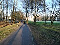
| The rifle park around 1910 | |
| Basic data | |
| place | Kiel |
| District | Südfriedhof |
| Created | 1903-1909 |
| Surrounding streets | Schützenwall, Westring, Kronshagener Weg |
| Buildings | High bunker, traffic training area |
| use | |
| User groups | Pedestrians , leisure |
| Park design | Ferdinand Hurtzig |
| Technical specifications | |
| Parking area | approx. 62,000 m² |
The Schützenpark is a green area in the Südfriedhof district of the Schleswig-Holstein state capital, Kiel . It is located southwest of the city center and runs parallel to Schützenwall from the junction of the BAB 215 on the Westring to Kronshagener Weg. The 6.2 hectare park area is around one kilometer long and on average only 62 meters wide. Harmsstrasse, Gellertstrasse and Hermann-Weigmann-Strasse divide the facility into four sections. There is a 6500 m² pond in the south-east, a play and sunbathing area, a children's playground and the rifle park bunker in the middle, and the Prüne training area in the north-east .
history
On the site, in front of the park, was the shooting range and festival area of the Great Green Rifle Guild , founded in 1412 , which was given a paddock on the Prüner Schlag in 1896 in exchange for the area that was then known as the Schützengärten . By then the Prüne brook had cut through the rural area like a valley and flowed into the Prüner pond. The town planners wanted to use this valley to drain the new development areas that were built around today's park.
The Schützenpark was laid out from 1903 under the direction of the city gardening director Ferdinand Hurtzig and is one of the oldest historical parks in the state capital. Initially, the park only extended from Boninstrasse to Harmsstrasse and was 1.6 hectares in size. The second and third parts of the park up to the level of Lutherstrasse were established in 1908 and 1909. Rain retention basins were excavated for drainage in these construction sections and, for the first time in Kiel, architectural elements were also introduced into the design of the park. When it was completed, it was 700 meters long and was considered one of the most beautiful parks in Kiel. The furnishings at the time with seating niches, terraces and pergolas were destroyed during the Second World War and not restored. There was another, somewhat smaller pond on today's lawn, which was filled in. When the Schützenwall was expanded to four lanes in the late 1960s, a strip of grass, the vegetation of which closed off the park opposite the Schützenwall, was removed.
Schützenpark bunker
The civilian version of the T 1100 troop crew bunker was built in 1943. In a basement and four floors above ground, up to 1,036 people found protection during the air raids on Kiel . After the war, the bunker was deconsolidated in 1949 and converted into an industrial building. The windows used at that time are now closed again. Today there are rehearsal rooms for music groups behind the two meter thick concrete walls.
Prüne traffic exercise area
The Prüne traffic training area is a training area for cyclists at the northeast end of the park. The operator is the Schleswig-Holstein State Traffic Watch Association .
photos

The rifle park in Kiel.

The rifle park in Kiel.

Rebuilding of the bunker in January 1949

Playground and bunker 2019

View from the skyscraper of the Federal Institute for Dairy Research to the Schützenpark 1976

View from the high-rise of the commercial vocational school on Westring in 1966

The pond in the rifle park
Winter in the Schützenpark 2019


.jpg)
.jpg)


Web links
Individual evidence
- ↑ Park series: Schützenpark - long, narrow and a real insider tip
- ↑ Documentation planning workshop Schützenpark Kiel
- ↑ Beautify the rifle park
- ↑ Schützenpark on kiel-wiki.de
- ^ The troop crew bunker of the Kriegsmarine in Kiel
- ↑ The Schützenpark bunker at bunker-kiel.de
- ↑ More beautiful rocking in the bunker
- ↑ Documentation planning workshop Schützenpark Kiel, page 22
Coordinates: 54 ° 19 ′ 6 ″ N , 10 ° 7 ′ 3 ″ E