
Herberstein Castle

Herberstein Castle is located in the municipality of Stubenberg near the Herberstein zoo . It stands high up on an east-west facing rock spur, which drops steeply to the north, in the Feistritz gorge . The fortified castle, not visible from a distance and difficult to access, is in a strategically favorable location.
The oldest parts of the castle date from the end of the 13th century. The small castle named Herwigstein after Herwig von Krottendorf was under the fief of the Stubenbergs . Otto von Hartberg was able to convert the fief into free own ( allod ) against payment and has since been considered the ancestor of the Herberstein .
Around 1400 the castle was extended by a mighty outer bailey, which included the Gothic St. Catherine's Chapel, which was built earlier. The outer bailey was expanded several times in the 15th century. In the middle of the 16th century, the castle was redesigned and expanded into a residential building with Renaissance elements to provide space for the numerous descendants. The magnificent knight's hall was built in the 17th century, and the deep moat was built over. In the middle of the 17th century, the Florentinerhof was built based on the Italian model and by the end of the century the Georgskapelle, gardener's house and meierhof were completed.
In the 17th and 18th centuries, around a fifth of Styria belonged to the manor of the Herberstein counts, and around 1000 farms were subject to interest at the castle. The castle is still owned by the Herberstein family today and serves as a residential and administrative center. Part of the facility can be viewed in guided tours.
The castle café and the magnificent historical gardens are further attractions.
The Gironcoli Museum is located in the park .
A defensive tower has been preserved on a hill north of the castle.
Web links
- Homepage of Herberstein Castle
- Entry on Herberstein, East Styria, Castle in the Austria Forum (in the AEIOU Austria Lexicon )
- Entry via Herberstein Castle to Burgen-Austria
photos

Herberstein Castle (July 2006)
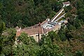
Herberstein Castle (August 2013)

Entrance to the castle
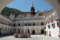
Castle courtyard, view from the entrance

Castle courtyard, view of the entrance


Coordinates: 47 ° 12 ′ 52.4 " N , 15 ° 48 ′ 38.7" E