
Rufling Castle

The Rufling Castle is located in the town district Rufling the town of Leonding in District Linz-Land (Ruflinger Road 213).
history
The first mention of a residence comes from 791. Under Odalsalh von Rudolfvingen it was owned by Passau. 1120 Otto and Hartwik Lengau from Grieskirchen are named as owners. In 1133 the residence came to the Meginhart and in 1154 to the Wilhering monastery . A Rudolfingen is mentioned in a deed between 1151 and 1161. In 1159 Rufling is mentioned as the property of Bishop Konrad von Passau. Mrs. Williburg, née Waxenberger, received Rufling in 1215 as a marriage property. Since her husband and son were murdered, the property fell to a relative. In 1280 Rufling came to the Linz citizen Heinrich von Jetzigner and in the same year to the brothers Heinrich and Otto von Lohnsdorf. In 1302 Rufling belonged to the Göttweig Abbey . In 1475 Rufling is guaranteed as a knight seat of the Stettner. In 1648 Rufling was the seat of the Vice Dominus and the Vice Cathedral Office.
The list of other owners is relatively long: 1754 Georg Josef Freiherr von Monstorf, 1755 Count Philipp Fieger, 1764 Maria Theresia Freiin von Pilati, 1825 Anton Ritter Grimburg, 1846 Wilhelm Grimus Ritter von Grimburg, 1849 Freiherr von Münch-Bellinghausen, 1872 Josef Nossberger , 1878 Franz Löbl, 1886 Anton Markl, 1898 Anton Chuchar, 1900 Jakob Penka, 1903 Eugenie Everats from Belgium, 1909 Max Everats, 1910 Therese Pöschl and Friedrich Pollak, 1911 Heinrich Kraus. In 1916 Rufling fell to the Alfons and Anna Wagenhofer family. Today Luis Wagenhofer and descendants of his siblings live in Rufling Castle.
Rufling Castle is not particularly prominent in history, apart from the fact that it was a lordly office and court until the end of the manorial rule in 1848. Its local importance is probably due to the fact that a large farm belonged to the castle, which is still operated with success today.
Rufling Castle today
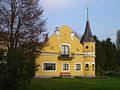
The castle emerged from a medieval knight's seat; in the second half of the 19th century it was brought into its present form. The now fully restored castle stands on an artificially created hill within a park. The ornamental garden, which is lower compared to the castle, gives the impression that there used to be a pond here, which enclosed the hill, but which was drained by the aforementioned embankment.
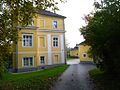
Today's palace building is three-story. The central axis is directed towards the former ornamental garden. This area lies below a wide terrace bordered by balustrades in front of the garden facade. A flight of stairs leads to an arbor with a portico resting on two columns . As can be seen from the differently designed windows on the courtyard side, the third floor was only added in the recent past.
The castle is covered with a hipped roof, which also includes the round bay window on the courtyard side. Presumably this used to be a round tower, which was transformed into a bay window for the entrance portal when it was redesigned. Above the entrance is the coat of arms of the previous owner Everats from Belgium.
The formerly much larger landscape park with forest and pasture land has become smaller due to sales. The mighty, protected landscape " court linden tree" is remarkable .
An outbuilding was converted into a villa at the beginning of the 20th century.

Entrance to Rufling Castle
Side view of Rufling Castle with portico
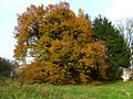
Court linden tree of Rufling Castle
Outbuilding of Rufling Castle


literature
- Eva Berger : Historic gardens of Austria: Upper Austria, Salzburg, Vorarlberg, Carinthia, Styria, Tyrol Gardens and parks from the Renaissance to around 1930 (Volume 2) . Böhlau, Vienna 2003, ISBN 978-3-205-99352-0 , p. 185 .
- Oskar Hille: Castles and palaces in Upper Austria then and now. Verlag Ferdinand Berger & Sons, Horn 1975, ISBN 3-85028-023-3 , p. 157 .
- Norbert Grabherr : Castles and palaces in Upper Austria. A guide for castle hikers and friends of home. 3rd edition . Oberösterreichischer Landesverlag, Linz 1976, ISBN 3-85214-157-5 .
Web links
Coordinates: 48 ° 16 ′ 36.1 ″ N , 14 ° 12 ′ 53.1 ″ E