Schneckenberg (Passau)
| Schneckenberg | ||
|---|---|---|
|
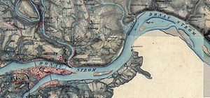
Original position sheet 569 Passau with the Schneckenberg |
||
| height | 373 m above sea level NHN | |
| location | Passau , Grubweg district | |
| Coordinates | 48 ° 34 '58 " N , 13 ° 29' 32" E | |
|
|
||
| Type | artificial debris | |
| Age of the rock | 235 | |
The Schneckenberg is a 373 meter high mountain in the Grubweg district of Passau . It is a wooded hill east of today's sports field and southwest of the adjacent square. It was created by Oberstjägermeister Leopold Anton Graf von Firmian, the brother of Prince Bishop Leopold Ernst Graf von Firmian, in connection with the gardens of the Firmianggut around 1780 as an artificial mound, around which a spiral-shaped path went up. His name is only recorded on historical maps, but not on the current official map. It is, however, eponymous for the district of the same name in the Passau district of Grubweg, for today's residential streets Obere and Untere Schneckenbergstraße as well as the sports facility and gym of VfB Grubweg. The heaped up area rises only around eight meters above the surroundings.
Individual evidence
- ↑ Local section Passau-Stadt from June 7, 2002
- ↑ Historical land map
- ^ Original position sheet
- ↑ Official card

