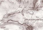
Schulthisserei Damm
On November 26, 1819, Damm, which at that time had around 1,100 inhabitants, had its own mayor's office and formed the fifth of five districts of the city of Aschaffenburg , was administratively separated from the city of Aschaffenburg and as a special rural community , in accordance with a resolution of the royal Bavarian government incorporated into the Aschaffenburg district court.
The border between the rural community of Damm or the district court of Aschaffenburg and the city of Aschaffenburg ran from the Main along the edge of the slope of today's Mörswiesenstrasse 9 in the former “Steinrutschen” tub, above the Mörswiese and along the Hanau - Aschaffenburg road to the curve on Schlotfegergrund, from there along the course of today's Reitzstraße to close to today's intersection Müllerstraße / Mühlstraße / Burchardstraße / Merlostraße, from there today's Merlostraße (at that time, like Mühlstraße only a field path) along to about the middle of Seestraße (then field path ), from there to the then place name sign of Damm, which stood on the way between Damm and Aschaffenburg at the height of today's property Dammerstraße 19, around the Dammer Friedhof (today Kurt-Gerd-Kunkel-Platz), from there to Schneidmühlweg, which already Back then it was called, and following its historical course to the cutting mill (at that time in the area of today's property Boppstraße 26 / Inselstraße 33 and 35), from there to where the mill canal of the Pfaffenmühle and the granulator fell back into the Aschaff , i.e. at the western end of the so-called Insel (today the Dämmer fire station is located there), up the Aschaff to the bridge along the way to Glattbach , along this path to today's motorway bridge and from there in Glattbach to the boundary of Glattbach, which is almost exactly on the 50th degree north latitude. The Schnepfenmühle, the Haselmühle, the Aumühle, the Windmühlenturm, the Pfaffenmühle, the Schneidmühle, the Auhof and the Holzhof as well as the then white paper factory and the Bavarian share brewery Aschaffenburg were located in the Aschaffenburg district. The part of the Aschaffenburg district, which came to be north of the railway line after the construction of the railway in 1854, is now part of the Damm district. The part of the former Damm district, which came to be located south of the railway line, is now part of the city center. The reincorporation to Aschaffenburg took place on July 1, 1901.
See also
Individual evidence
- ^ Wilhelm Volkert (ed.): Handbook of Bavarian offices, communities and courts 1799–1980 . CH Beck, Munich 1983, ISBN 3-406-09669-7 , p. 600 .

