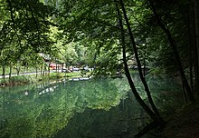
Black Lake (Satteins)
| Black lake | ||
|---|---|---|

|
||
| The small island in the Black Lake | ||
| Geographical location | Satteins | |
| Drain | Reiherbach → Bolabach → Nafla | |
| Data | ||
| Coordinates | 47 ° 14 '17.2 " N , 9 ° 39' 36.3" E | |
|
|
||
| Altitude above sea level | 553 m above sea level A. | |
| surface | 0.65 ha | |
| length | 180 m | |
| width | 20 m | |
| Maximum depth | 4.8 m | |
The Black Lake is located in the municipality of Satteins in the Austrian state of Vorarlberg .
Geographical location
The body of water is in the immediate vicinity of the municipal boundary of Satteins with the municipalities of Göfis and Rankweil, which are also in the Feldkirch district . The lake is estimated to be around 180 meters long and an average width of around 20 meters. It occupies an area of about 0.65 hectares. From a water depth of 2 meters, it consists almost entirely of thick mud. The lake is about 4.80 m deep. The water surface has approximately the shape of a boomerang, with a small island with a single tree on it on the south side of the lake. A small promenade leads around the lake.
Walgaustraße L 50 (referred to as Rankweiler Straße in this area) runs along the lakeshore , a state road on which there is a rest station in the area of the lake, which is managed in summer. This road connects the Vorarlberg Rhine Valley with the Walgau and is known as a popular route for motorcyclists.
The lake collects water from the surrounding mountains and therefore has no typical inlet. The drainage of the lake is only intended for the drainage of rainwater and is otherwise dry.
history
The Black Lake was only created in the late Middle Ages by a landslide from the Spiegelstein. The natural scar of the Verheitenschrofen , which is still visible today, is a witness of this major medieval event .
At the end of April 2009, a research team from the Underwater Archeology Working Group at the University of Vienna and the private company Ardis Archäologie im See researched a lost Roman road.
Individual evidence
- ↑ a b Investigation by the state of Vorarlberg (PDF; 831 kB)
- ↑ Description ( page can no longer be accessed , search in web archives ) Info: The link was automatically marked as defective. Please check the link according to the instructions and then remove this notice. of the underwater archaeological project at the Black Lake. (PDF file, 64 kB)
- ↑ Article from vol.at on the investigation of the Black Lake
Web links
- Video of a helicopter flight over the Black Lake on vorarlbergvonoben.at.
- Measurement data of the Black Lake from the state of Vorarlberg (PDF file; 812 kB)

