
Swing barrier

The swing barrier is located at the mouth of the swing in the Lower Elbe near Stadersand. It is part of the flood protection concept on the Tiedeelbe , which is influenced by the tides , between the Geesthacht barrage and the mouth of the Elbe into the North Sea, which was developed as a result of the severe storm surge in 1962 .
The barrage , built from June 1969 to August 1971, protects the villages on the Schwinge, especially the Hanseatic city of Stade . The construction costs of the barrage amounted to the equivalent of around 7.5 million euros. Around 7000 m³ of reinforced concrete, 900 t of reinforcing steel and 1200 t of steel sheet piling were used.
The structure is 34 m wide and just as deep. The shipping opening, which has a clear width of 16 m, can be closed by two two-part mitred gates . The jamb depth is 4.5 m below sea level , the upper edge of the stem gate is 7.6 m above sea level. The barrage is closed from a water level of 2.4 m above sea level. There is a double bascule bridge above the barrage that is not in operation.
The barrage is operated by the Stade site of the Lower Saxony State Agency for Water Management, Coastal Protection and Nature Conservation (NLWKN).

Swing barrier at low tide , view towards the Schwing estuary
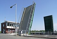
The bascule bridge of the barrage is out of order


Web links
- The swing barrier (NLWKN)
Coordinates: 53 ° 37 ′ 29 ″ N , 9 ° 30 ′ 51 ″ E