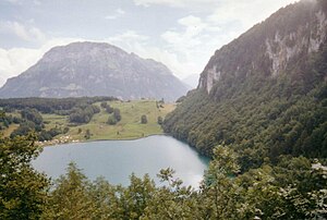
Seelisbergsee
| Seelisbergsee | ||
|---|---|---|

|
||
| Seelisbergsee with Fronalpstock | ||
| Geographical location | Canton of Uri | |
| Tributaries | Submarine infiltration | |
| Drain | Bach to the small Seelisbergsee | |
| Places on the shore | Seelisberg | |
| Data | ||
| Coordinates | 686 259 / 201459 | |
|
|
||
| Altitude above sea level | 738 m above sea level M. | |
| surface | 18 ha | |
| length | 800 m | |
| width | 350 m | |
| Maximum depth | 37 m | |
The Seelisbergsee , briefly referred to as Seeli on the map of Switzerland , is a lake below the village of Seelisberg in the canton of Uri , Switzerland .
The lake is about 18 hectares in size, 700 to 800 m long, 350 m wide and has a depth of 37 m, which is designed like a tub.
location
The Seelisbergsee is located at 738 m southwest of the "knee" of the Vierwaldstättersee , where it merges into the Urnersee . The Rütli , according to legend, the birthplace of the Swiss Confederation , is in the immediate vicinity. The lake is located in a depression on the steep north slope of Niederbauen-Chulm (1923 m). The inflow takes place via underground infiltration, then the water flows into the small lake, from there underground to the Vierwaldstättersee, where it emerges again below the surface of the water between Rütli and Bauen. The subsoil in the area of the discharge is quite rugged and probably has a widely branched cave system.
use
At the north end between Seelisbergsee and -wyher there is a campsite (only for tents) and a lido. The campsite has around 40 tents, and it is also possible to rent smaller boats. The water temperatures in summer are above the values of Lake Lucerne. This pre-alpine lake is also very interesting for hobby fishing.
Emergence
There is a legend about the origin of the Seelisbergersee: A "field of flowers" was flooded as a curse for an atrocity committed by its lordly owner. This is how the Seeli was created. There could be a grain of truth in this story. There are indications that the water level of the lake has varied in the course of its history.
In 1916 it was planned to feed the Isitalbach in order to turn the lake into a reservoir for a power station. The plan failed due to the difficult drainage system and had to be abandoned. In 1937, the lake was lowered again, which was 2 meters higher during construction. This had a negative impact on the biodiversity near the shore.
