Segosero
| Segosero Сегозеро, Seesjärvi |
|||||||
|---|---|---|---|---|---|---|---|
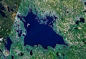
| Satellite image of the Segosero | |||||||
|
|||||||
|
|
|||||||
| Coordinates | 63 ° 18 ′ 0 ″ N , 33 ° 45 ′ 0 ″ E | ||||||
| Data on the structure | |||||||
| Data on the reservoir | |||||||
| Water surface | 906 km² | ||||||
| Storage space | 21.5 km² | ||||||
| Catchment area | 7th 460 km² | ||||||
The Segosero ( Russian Сегозеро ; Karelian and Finnish Seesjärvi ) is an originally natural lake in the Republic of Karelia in northwestern Russia , which was converted into a reservoir by damming .
The Segosero catchment area covers 7,460 km². The most important tributaries of the Segosero are Woloma and Luschma . The Segescha drains the lake to the northeastern Wygosero . Following the completion of a hydropower plant on the Segescha, the water area of the Segosero was increased from 815 km² to 906 km². The annual fluctuations in the water level are 2.4 m. The lake is frozen over between December and May.
literature
- A. Gorkin and others: Geografija Rossii: Enziklopeditscheski slowar . Bolschaja Rossijskaja enziklopedija, Moscow 1997, ISBN 5-85270-276-5 , p. 531. (Russian)
Web links
Commons : Segosero - collection of images, videos and audio files
- vedlozero.ru: Segosero (Russian)
Individual evidence
- ↑ Segosero in the State Water Directory of the Russian Federation (Russian)
- ↑ Article Segosero in the Great Soviet Encyclopedia (BSE) , 3rd edition 1969–1978 (Russian)

