Selfoss (waterfall)
| Selfoss | ||
|---|---|---|
|
Selfoss |
||
| Coordinates | 65 ° 48 '17.6 " N , 16 ° 23' 13.1" W | |
|
|
||
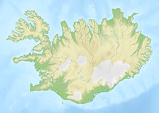
| place | Kópasker , Reykjahlíð , Iceland | |
| height | 10 m | |
| flow | Jökulsá á Fjöllum → Öxarfjörður ( Greenland Sea ) | |
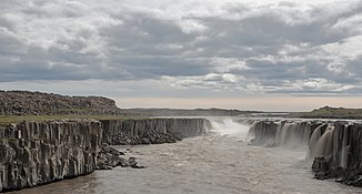
The Selfoss is a waterfall in northern Iceland . It has nothing to do with the town of the same name in the south between Hveragerði and Hella .
Location on Jökulsá á Fjöllum
The water of the Jökulsá á Fjöllum first plunges 10 m over the Selfoss and after about one kilometer over the 45 m high Dettifoss . The third waterfall is the 27 m high Hafragilsfoss a few hundred meters downstream. Finally, the river flows through the Jökulsárgljúfur National Park , which has been part of the Vatnajökull National Park since 2008 , and flows past the Ásbyrgi Gorge. Like the other two, this waterfall has been under nature protection since 1996 .
Selfoss and Dettifoss can be reached on the west side via a new asphalt road (Dettifossvegur, road 862) and on the east side via an older gravel road (Hólsfjallavegur, road 864). The waterfall, like the Dettifoss, is located on Demantshringurinn (about a diamond tour), a well-known tourist route around Húsavík and Lake Mývatn in northern Iceland.
See also
- List of waterfalls in Iceland
- Selfoss , the southern Icelandic city of the same name
literature
- Jón Kr. Gunnarsson: Íslenskir fossar. Icelandic waterfalls. Skuggsjá, Hafnarfjörður 1992, ISBN 9979-829-00-1 , pp. 214-215.
Web links
Individual evidence
- ↑ Auglýsing um friðlýsingu Dettifoss, Selfoss and Hafragilsfoss and nágrenni í Öxafjarðarhreppi. Retrieved October 28, 2017 (isl.).


