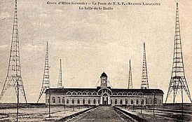
Lafayette transmitter
|
Lafayette transmitter
|
|||||||
|---|---|---|---|---|---|---|---|
| Basic data | |||||||
| Place: | Marcheprime | ||||||
| Department: | Gironde | ||||||
| Region: | Nouvelle-Aquitaine | ||||||
| Country: | France | ||||||
| Coordinates: 44 ° 42 ′ 31 ″ N , 0 ° 48 ′ 49 ″ W. | |||||||
| Use: | Telecommunication system | ||||||
| Demolition : | 1953 | ||||||
| Data on the transmission system | |||||||
| Number of towers / masts: | 8th | ||||||
| Construction time: | 1922 | ||||||
| Operating time: | 1922-1944 | ||||||
| Send type: | Morse code | ||||||
| Shutdown : | 1944 | ||||||
|
|||||||
| Position map | |||||||
|
|
|||||||
The Lafayette transmitter was a large message transmission facility south of the Croix d'Hins train station near Marcheprime , Nouvelle-Aquitaine , France . The Lafayette transmitter was a so-called pop - spark transmitter and used a transmitting antenna, which was carried by eight free-standing steel lattice towers with a triangular cross-section. After the Eiffel Tower, these towers were the tallest free-standing towers in Europe .
In 1944 the Lafayette transmitter was destroyed by the retreating German troops and in 1953 the last of the towers was demolished.


