
Seoullo 7017

| |
Seoul, South Korea |
| Korean spelling | |
|---|---|
| Korean alphabet : | 서울 로 7017 |
| Revised Romanization : | Seoullo 7017 |
| McCune-Reischauer : | Sŏullo 7017 |
.jpg)
Seoullo 7017 ( Korean 서울 로 7017 ) is a former flyover over the railway tracks at Seoul Central Station , which was rededicated and redesigned as part of an urban development project and has been used as a pedestrian crossing and a park for residents of Seoul ( 서울 ) and tourists since May 2017 is available.
Origin of name
The designation “Seoullo 7017” results from the name of the city of Seoul, the Korean term “ro” ( 로 ; the initial “rieul” ㄹ was assimilated here because of the final consonant from “Seoul” to “l”) for street or in the direction, the number 70 for the year 1970, in which the elevated road was built, and the number 17 for the year 2017, in which the street was given to the residents of Seoul as a "walkway" and "botanical garden". In the logo of the urban development project, in the lettering “Seoullo since 7017”, the double letters “l” are executed like two legs of a pedestrian.
geography
Seoullo 7017 is located right in the center of Seoul at the city's main train station. The approximately 1 km long section of the former 1.15 km long elevated road connects the Hangangno-dong district, which is divided into two halves by the railway line . The route is divided into five sections, known from west to east as Malli-dong Square, Rose Square, Toegye-ro Square, Magnolia Square and Seoul City Wall .
history
In the 1970s, the city of Seoul had to cope with an ever-increasing volume of traffic due to a growing middle class and the associated increase in cars. City planners currently saw the solution to the traffic problem in the construction of elevated roads in order to get the traffic flowing more smoothly and thus to be able to increase the throughput of vehicles on certain route sections. Around 100 elevated roads were built in the city in a row. But over the years one had to take note that the quarters near the elevated roads became slumy due to the spatial isolation. In addition, research came to the conclusion that the elevated roads did not produce the desired effect that was expected. With the demolition of the Tteokjeon ( 떡전 ) in the Dongdaemun-gu ( 동대문구 ) district in 2000, a paradigm shift occurred, as a result of which around 30% of the elevated roads were demolished in 2017 and the districts were revitalized in social terms.
Demolition or renovation, the question was also raised in the early 2000s for the Hochstraße at the main train station, especially since the street was no longer able to withstand the stresses of traffic due to its age. The city council of the city of Seoul then decided in 2014 to use the model of the High Line in New York City to prepare the elevated street as a space for pedestrians and as a place of relaxation for the urban population. The elevated road was rebuilt and prepared in record time and opened on May 20, 2017 by the Mayor of Seoul City, Park Won-soon, under the name Seoullo 7017.
The construction
The park or botanical garden, as the around 1 km long structure is also known, has access to 17 pedestrian paths, including the four former driveways of the elevated road, two of which have been shortened and provided with a staircase. 228 different types of trees, bushes, flowers and other plants were planted in small and large pots along the entire route, a total of 24,085 in number. Small ponds, seating and pavilions invite you to linger. At night the park is illuminated in a bluish light, while solar panels provide the necessary electricity throughout the day.
The structure, equipped with 29 surveillance cameras for security reasons, cost around 59 billion won , around 45 million euros , of which around 40% of the construction costs were spent on earthquake security alone.
The planning of the renovation and the design was taken over in 2015 by the Dutch architects MVRDV , which called their project “Seoullo 7017 Skygarden”.
Photo gallery
- Seoullo 7017

Two former feeders as a pedestrian paradise

One of 17 pedestrian walkways connected to Seoullo 7017
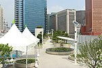
Planted pots, small ponds and pavilions to linger

Seoullo 7017 at night


literature
- Han Eun-ju: Seoullo 7017 . The “sky bridge” of the city. In: Koreana . Volume 12, No. 3. The Korea Foundation , 2017, ISSN 1975-0617 , p. 36–41 (German-language edition).
Web links
- Homepage . Seoullo 7017,accessed November 19, 2017.
- Homepage . Seoullo 7017,accessed November 19, 2017(Korean).
Individual evidence
- ↑ a b Han: Seoullo 7017 . In: Koreana . 2017, p. 60 .
- ↑ Homepage . Seoullo 7017 , accessed November 19, 2017 .
- ↑ 전국 안내 지도 . 우성 지도 , Seoul 1999, ISBN 89-85762-10-9 , pp. 32 ( National Guide Map ).
- ↑ Landscaping and Amenities . Seoullo 7017 , accessed November 19, 2017 .
- ↑ a b Han: Seoullo 7017 . In: Koreana . 2017, p. 38 .
- ↑ a b Han: Seoullo 7017 . In: Koreana . 2017, p. 39 .
- ↑ a b c Seoullo 7017, overpass-turned-park, to open in May . In: The Korea Times . May 19, 2017, accessed November 19, 2017 .
- ↑ Han: Seoullo 7017 . In: Koreana . 2017, p. 41 .
- ↑ Seoullo 7017 sky garden . MVRDV , 2015, accessed on November 19, 2017 (English).