Seraverna
| Seraverna | ||
|---|---|---|
|
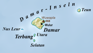
Map of the Damar Islands |
||
| height | 655 m | |
| location | Teun , Indonesia | |
| Coordinates | 6 ° 58 '14 " S , 129 ° 8' 33" O | |
|
|
||
| Type | Stratovolcano | |
| Last eruption | 1904 | |
| particularities | Highest mountain Teuns | |
The Serawerna ( Indonesian Gunungapi Serawerna , also Teun ) is a stratovolcano on the east coast of the Indonesian island of Teun . At 655 m it is the highest mountain on the island. The active crater is also called Seraverna. To the north-northeast is another, smaller crater.
Outbreaks have been reported since the 17th century. The largest eruption in 1660, which also claimed deaths, created pyroclastic currents . The last eruption took place in 1904. There were further eruptions in 1659, 1663 and 1693. The volcano is classified as a potential trigger of tsunamis .
Between 1979 and 1983, the entire population of Teun was forcibly relocated to Seram . The measure was justified with the threat from the active volcano.
Serawerna is one of the numerous volcanoes of the Banda Arch - the closest are 50 km northeast of the Nila (on the island of Teun ) and 80 km west of the Wurlali (on Damar ).
Individual evidence
- ^ Map of Pulau Nila
- ↑ Gunung Bagging
- ↑ Serawerna in the Global Volcanism Program of the Smithsonian Institution (English)
- ↑ Tsunamis in Indonesia ( Memento of the original from December 3, 2016 in the Internet Archive ) Info: The archive link was inserted automatically and has not yet been checked. Please check the original and archive link according to the instructions and then remove this notice.
- ↑ Mark Janse, Sijmen Tol: Language Death and Language Maintenance: Theoretical, Practical, and Descriptive Approaches , 2003, pp. 49 ff.

