Wurlali
| Wurlali | ||
|---|---|---|
|
The Wurlali |
||
| height | 868 m | |
| location | Damar , Indonesia | |
| Coordinates | 7 ° 7 ′ 30 ″ S , 128 ° 40 ′ 30 ″ E | |
|
|
||
| Type | Stratovolcano | |
| rock | Andesite | |
| Last eruption | 1892 | |
| particularities | Highest mountain Damars | |

Map of the Damar Islands
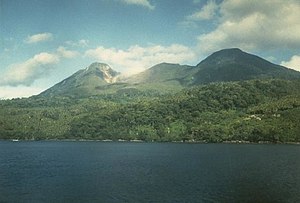
The Mount Wurlali ( Indonesian Gunung Mount Wurlali even Wuwapla ) is a stratovolcano on the east coast of the Indonesian island of Damar . At 868 m, it is the highest mountain on the island.
The Wurlali is the most active volcano of the Banda Arch in historical times . It was formed at the northern end of a five kilometer wide caldera . Sulfur escapes on the southwest flank of the two craters. The last eruption took place in 1892.
In 1993 there was an earthquake, landslides and smoke. 4000 people were evacuated. On January 23, 2003 there was an earthquake with a magnitude of 6.1. Hot springs emerge near the beach, southwest of the volcano.
Individual evidence
- ↑ Wurlali . In: Global Volcanism Program . Smithsonian Institution . Retrieved April 6, 2013.
- ^ Vulcano live

