Teun
| Teun | ||
|---|---|---|
| The Damar Islands | ||
| Waters | Banda Lake | |
| Archipelago | Damar Islands | |
| Geographical location | 6 ° 58 '15 " S , 129 ° 8' 41" O | |
|
|
||
| length | 4.4 km | |
| width | 4.3 km | |
| surface | 14.18 km² | |
| Highest elevation | Serawerna 655 m |
|
| Residents | 1612 (2010) 114 inhabitants / km² |
|
| main place | Isu | |
Teun ( Indonesian Pulau Teun , also Teon) is one of the Indonesian Barat Daya Islands in the Banda Sea .
geography
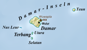
Teun is the northernmost and easternmost of the Damar Islands and is 49 kilometers east-northeast of their main island, Damar . It has an area of 14.18 km². Geographically, Teun belongs to the Damar Islands, but administratively it is part of the district ( Kecamatan ) Teun Nila Serua , together with the islands of Nila and Serua . The district belongs to the administrative district ( Kabupaten ) Maluku Tengah , Maluku Province . Damar Islands and the islands of Nila and Serua to the east belong to the inner Bandabogen , a chain of islands of volcanic origin.
In the center of Teun lies the active Serawerna volcano at 655 m .
Population and history
There were originally five villages on Teun: Watludan ( Watludang ), Jafila, Isa, Mesa and Lajoni. In three villages the inhabitants spoke the Austronesian language Teun , which was also spoken in Bumey , in the southwest of the island of Nila. It belongs to the Teun-Nila-Serua ( TNS ) language group , which was used on the islands of Teun, Nila and Serua, with Teun being more different from the other two dialects, Nila and Serua.
Mesa (744 inhabitants) and Isu (868 inhabitants) are current Desa .
In 1979, 1,175 households from Teun were relocated to Seram because of the threat from the volcano . The rest of the population followed between 1982 and 1983.
Individual evidence
- ↑ Colin R. Trainor: Birds of Damar Island, Banda Sea, Indonesia , November 22, 2006
- ↑ Map of the Southwest Moluccas ( Memento of the original from November 22, 2011 in the Internet Archive ) Info: The archive link was inserted automatically and has not yet been checked. Please check the original and archive link according to the instructions and then remove this notice.
- ↑ a b Map of Pulau Nila
- ↑ Gunung Bagging
- ^ A b Mark Janse, Sijmen Tol: Language Death and Language Maintenance: Theoretical, Practical, and Descriptive Approaches , 2003, p. 49 ff.
- ↑ Penduduk Indonesia menurut desa 2010 ( Memento from March 27, 2014 in the Internet Archive ) (Indonesian; PDF; 6.0 MB), accessed on April 24, 2014

