Nus Leur
| Nus Leur | ||
|---|---|---|
| The Damar Islands | ||
| Waters | Banda Lake | |
| archipelago | Damar Islands | |
| Geographical location | 7 ° 13 ' S , 128 ° 24' E | |
|
|
||
| Number of islands | 2 | |
| length | 4.1 km | |
| width | 1.8 km | |
| Land area | 33 ha | |
| total area | 6 km² | |
| Residents | uninhabited | |
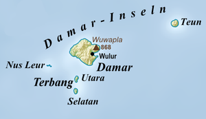
Nus Leur ( Noes Leoer ) is the only atoll in the Indonesian Damar Islands area in the Banda Sea , at the western end of the archipelago.
geography
The uninhabited atoll is 15.7 km southwest of the main island of Damar . It has two islands of almost the same size, each with areas between 16 and 17 hectares . The Damar Islands are part of the Barat Daya Islands and thus the inner Banda Arch , a chain of islands of volcanic origin. The Damar Islands form the sub-district ( Kecamatan ) Damar , which belongs to the administrative district ( Kabupaten ) of the southwestern Moluccas ( Maluku Province ).
Individual evidence
- ↑ Map of the Southwest Moluccas ( Memento of the original from November 22, 2011 in the Internet Archive ) Info: The archive link was inserted automatically and has not yet been checked. Please check the original and archive link according to the instructions and then remove this notice.

