
Severny Island
| Severny Island | ||
|---|---|---|
 |
||
| Waters | Arctic Ocean | |
| Archipelago | Novaya Zemlya | |
| Geographical location | 75 ° N , 60 ° E | |
|
||
| length | 570 km | |
| width | 115 km | |
| surface | 47,300 km² | |
| Highest elevation | Peak Sedova 1547 m |
|
| Residents | uninhabited | |
 |
||

The Severny Island ( Russian Северный остров / Severny ostrow , scientific transliteration Severnyj ostrov , translated North Island ) is the northern of the two main islands of the Russian archipelago of Novaya Zemlya in the Arctic Ocean .
With 47,300 km² it is the fourth largest island in Europe. Severny Island is surrounded by the Barents Sea to the west and the Kara Sea to the east . It is only separated from Yuzhny Island by the very narrow Matochkin Strait . The largest elevation is 1547 meters high.
Due to its location between 73 and 77 degrees north latitude, it is heavily glaciated . The largest contiguous glacier mass has a size of 19,800 km². It thus represents the largest ice cap on earth, only the glaciers of Antarctica and Greenland called ice sheets are larger . There are also hundreds of smaller glaciers with a total of 3,900 km². The ice is up to 400 m thick; many glaciers end in the sea and give off icebergs there.
The island was formerly inhabited by the Nenets , but most of them were relocated during nuclear tests in the 1950s . Today there is a Russian army base and port on the island.
Vladimir Russanov achieved the first complete circumnavigation of the island in 1910 on board the Dmitri Solunski .
Photo gallery

Cape Schelanija, northern tip of the North Island (76 ° 57'N, 68 ° 35'E)
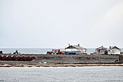
Cape Schelanija, research station of the "Russian Arctic" National Park
(with polar bears)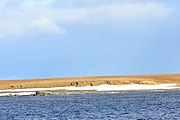
Barents Bay:
Region where the grave of Willem Barents is believed to be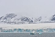
Inostranzewa Bay (German: "Bay of Foreigners"):
Inostranzewa Glacier (76 ° 30'N, 60 ° 5'E)


