
Sierra Estrella
| Sierra Estrella | ||
|---|---|---|
 |
||
| Highest peak | Hayes Peak ( 1375 m ) | |
| location | Arizona, USA | |
|
||
| Coordinates | 33 ° 16 ′ N , 112 ° 17 ′ W | |

The Sierra Estrella (Spanish for Star Mountains , O'Odham : Komaḍk , Maricopa : Vii Lyxa , Yavapai : Wi: kchasa ) is a mountain range southwest of Phoenix ( ˈfiːnɪks ), the capital of Arizona in the United States of America (USA) .
description
Most of the Sierra Estrella belongs to the Gila River Indian reservation , but 5800 hectares were placed under federal administration as the Sierra Estrella Wilderness .
Temperatures in the upper mountain areas are usually eight to ten degrees lower than in the valley. Therefore, snow can be seen at the highest points once or twice a year.
The Phoenix International Raceway is located on the northern edge of the mountains .
Surveys
The highest mountains of the Sierra Estrella from NW to SE are:
- Hayes Peak 1375 m , in honor of Ira Hayes , US Navy
- Montezuma Sleeping
- Butterfly Mountain, 4119 ft
- Quartz Peak, 4052 ft
- Montezuma Peak, 4,337 ft
photos
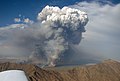
Fire in the Gila River Valley, southwest of Phoenix, (Rainbow Valley, Sierra Estrella Mountains)
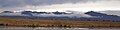
Sierra Estrella Mountains from Laveen, Arizona, January 2004, Hayes Peak right
