
Solar eclipse of January 15, 1991
| Solar eclipse of January 15, 1991 | |
|---|---|
 Animation of the annular solar eclipse from November 15th, 1991 |
|
| classification | |
| Type | Ring-shaped |
| area |
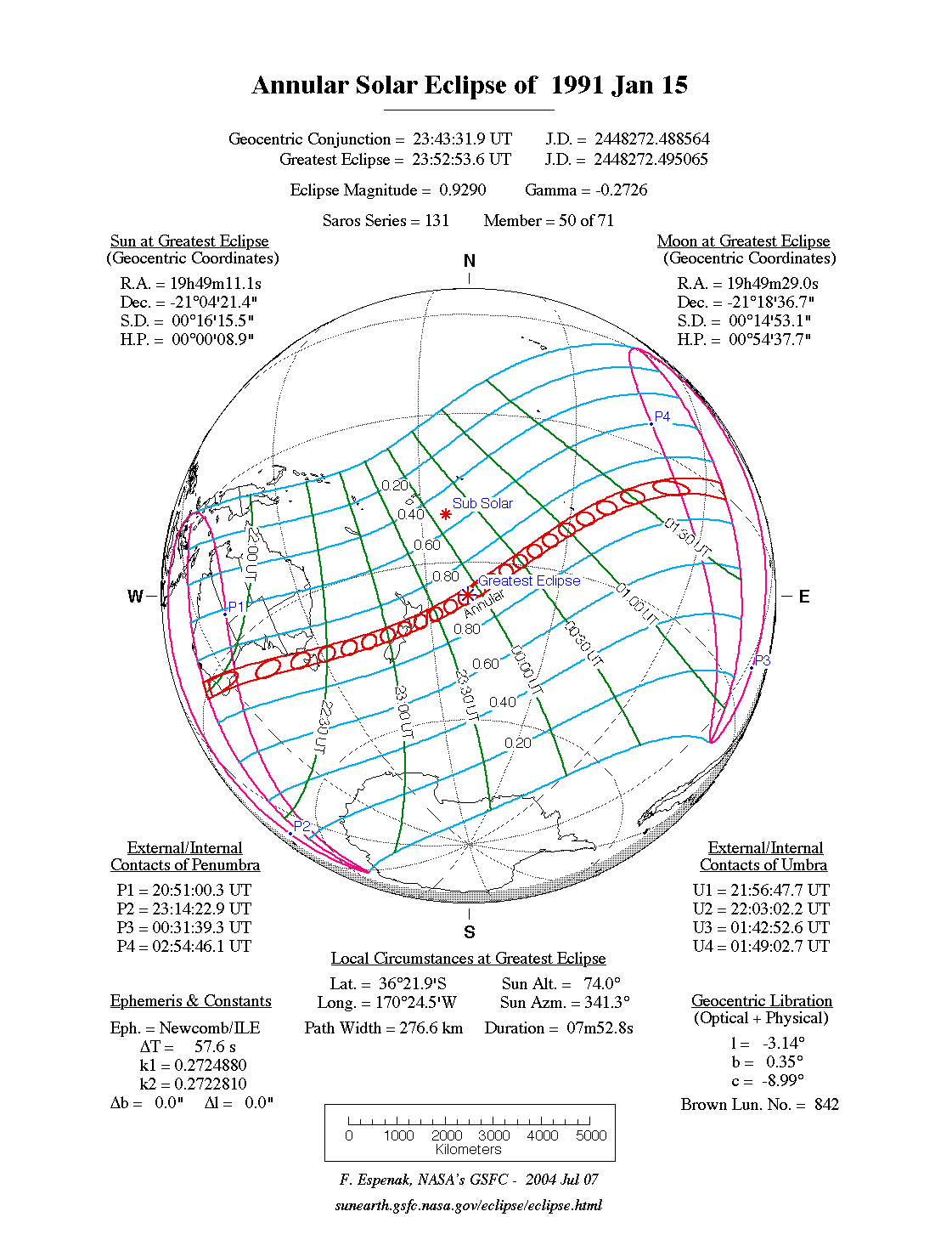
Australia , Pacific Ocean , East Antarctica Annular: South West Australia , Tasmania , New Zealand , South Pacific |
| Saros cycle | 131 (49 of 70) |
| Gamma value | −0.2726 |
| Greatest eclipse | |
| Duration | 7 minutes 52.8 seconds |
| place | South pacific |
| location | 36 ° 22 ′ S , 170 ° 24 ′ W |
| time | January 15, 1991 11:52:54 PM UT |
| size | 0.9290 |
During the annular solar eclipse on January 15, 1991 , the central line ran south of Australia and then crossed New Zealand and the South Pacific Ocean. In Western Australia , the solar eclipse occurred during sunrise. In Eastern Australia and New Zealand you could see the entire course of the morning eclipse. The ring-shaped zone stretched across the Cook Strait, which separates the two main New Zealand islands . Across New Zealand, at least 70 percent of the solar disk was covered. The New Zealand capital Wellington was in the ring-shaped zone.
This solar eclipse belongs to the Saros cycle 131, which will include a total of 70 eclipses. Saros 131 started on August 1, 1125 with a small partial solar eclipse in the Arctic Ocean north of Canada. The first eclipses were 22 partial in the northern hemisphere. This is followed by 6 total, 5 hybrid and 30 annular solar eclipses. The conclusion is formed by 7 partial eclipses in the southern hemisphere of the earth. The cycle ends on September 2, 2369 with a small partial solar eclipse in Antarctica , far south of Australia.
Web links
|
Previous solar eclipses:
|
Later solar eclipses:
|
|||||||||
| September 11, 1988 (circular) |
March 7, 1989 (partial) |
August 31, 1989 (partial) |
January 26, 1990 (circular) |
July 22, 1990 (total) |
January 15, 1991 (circular) |
July 11, 1991 (total) |
January 4, 1992 (ring-shaped) |
June 30, 1992 (total) |
December 24, 1992 (partial) |
May 21, 1993 (partial) |
|
|
|
|
|
|
|
|
|
|
|
|
| Lists: 20th century • 21st century • All lists | ||||||||||