
Southern Expressway
| Southern Expressway | |
|---|---|

|
|
| Basic data | |
| Operator: | Transport SA |
| Start of the street: |
Bedford Park ( Adelaide ) ( SA ) ( 35 ° 1 ′ S , 138 ° 34 ′ E ) |
| End of street: |
Old Noarlunga ( SA ) ( 35 ° 10 ′ S , 138 ° 30 ′ E ) |
| Overall length: | 21 km |
|
States : |
|
 |
|

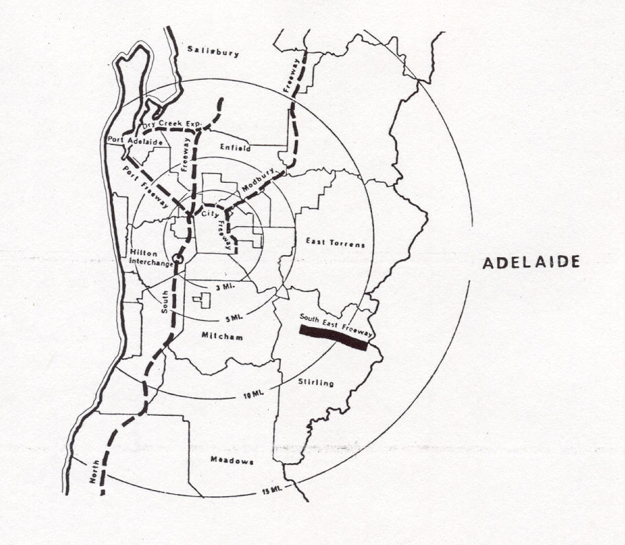
The Southern Expressway is an urban freeway south of Adelaide in the southeast of the Australian state of South Australia . It serves as a relief road for the Main South Road between the southwestern suburbs of Bedford Park and Old Noarlunga . Depending on the time of day, the motorway is only released in one direction. At 21 km, it is the longest road in the world with a reversible direction of travel. It runs under the numbering M2.
course
The Expressway branches off the Main South Road (A13) in Bedford Park and runs parallel to it to the south. Shortly before Old Noarlunga it meets the Main South Road again and ends.
business
The expressway is open to traffic 21 hours a day, 10.5 hours in each direction. On weekdays it is open in the mornings (2:00 a.m. - 12:30 p.m.) to the north, as well as on the weekends in the afternoon (2:00 p.m. - 12:30 a.m.). In a southerly direction, it can be used on weekday afternoons (2:00 p.m. - 12:30 a.m.) and on weekends in the mornings (2:00 a.m. - 12:30 p.m.). At the other times (0:30 a.m. - 2:00 a.m. and 12:30 p.m. - 2:00 p.m.) it is completely closed, with the exception of Saturday morning, when the direction of travel does not change. The weekend rule also applies on bank holidays during the week.
The closing times are used to rearrange the traffic lights and entrance gates. In addition, the entire route is searched for vehicle parts and broken down vehicles by a towing company during this time.
The elaborate traffic control technology on the sign gantries does not always work properly and so there was always criticism of incorrect advertisements.
history
The Southern Expressway is part of a north-south motorway link that was planned in the Metropolitan Adelaide Transport Study (MATS) completed in 1965 as a bypass of the capital from Dry Creek in the north to Old Noarlunga in the south. The MATS plans proved unpopular and in 1971 all plans for new highways in Adelaide were postponed for 10 years. In 1983 the plan for a motorway north of Darlington was abandoned and the land that had already been acquired for this purpose was gradually sold again.
In 1984 the state government of South Australia announced plans for a third major thoroughfare in south Adelaide. In 1987 the project was split into two construction phases, with the first phase in the expansion of Main South Road and Marion Road in the Darlington area and the second phase in the construction of a new road from Darlington to Reynella . Phase 1 was completed in 1994 with the expansion of Main South Road to 8 lanes between Ayliffes Road and Seacombe Road and the widening of Marion Road to 6 lanes between Main South Road and Sturt Road.
Phase 2 became the Southern Expressway, which in turn was built in two stages: the first from Darlington to Reynella and the second from Reynella to Old Noarlunga. The street was designed as a one-way street with alternating direction of travel, with the expansion of a second direction of travel in the substructure already planned. Essentially, the road was built on the route of the unrealized Noarlunga Freeway .
Construction began in July 1995 and the first phase of construction began on December 17, 1997. The second construction phase was started in February 1999 and opened to traffic on September 9, 2001.
While the Expressway is a blessing for the Adelaide residents, who live well south of the city center, it only begins 15 km south of the city center. This fact, together with the changing one-way street regulations and a number of compromises in the routing, always raised the question of the real meaning of the new urban motorway.
In 2007 the Howard government promised a grant of AU $ 100 million to expand the expressway to two directions, but was not re-elected.
The expansion was approved in 2010 and began in 2011. Since January 2012, there have been occasional line closures for this purpose.
Expansion for both directions of travel
On February 17, 2010, Prime Minister Mike Rann announced the AU $ 445 million project, which also included an AU $ 75 million motorway junction in Darlington (which was later canceled). The cancellation was due to the planning of a large freight yard in Darlington, in the course of which the government realized that they would have to build an AU $ 50 million section of road, which would later have to be demolished when the expressway was expanded for two directions.
The new lanes are being created entirely on the west side of today's road. Four lanes north will be created between Reynella and Marion Road. As soon as its construction is finished, the expressway will be opened continuously in both directions, so that the confusion of residents, as well as that of visitors, about opening times and driving directions will disappear. In addition, the connections will be added so that you can drive in and out of each exit in both directions.
After completion of the work, the newly designed expressway is to be opened to traffic in 2014.
Exits and crossings
|
Southern Expressway |
|||
| Exit to the south | Distance from Bedford Park (km) |
North exits | |
|
Beginning of the Southern Expressway on from Main South Road |
0 km |
End of Southern Expressway confluence with Main South Road to and into the city |
|
| no exit |
City via Main South Road South Road |
||
| no exit | 0.5 km |
City via Marion Road Marion Road |
|
| Reynella, Woodcroft Panalatinga Road South Road |
5.6 km | no exit | |
| Lonsdale Sherrifs Road |
9.9 km | Lonsdale Sherrifs Road |
|
| Noarlunga Center, Christie Downs Beach Road |
14.3 km | Noarlunga Center, Christie Downs Beach Road |
|
| Old Noarlunga, Victor Harbor Main South Road |
21.0 km | no exit | |
|
End of Southern Expressway joins Main South Road to and from |
Beginning of the Southern Expressway on from Main South Road |
||
Bridges and underpasses

The 15 bridges over the expressway are from south to north:
| No. | Surname | settlement | Type |
|---|---|---|---|
| 1 | Seacombe Road | Darlington | cars |
| 2 | Majors Road | O'Halloran Hill | cars |
| 3 | Glenthorne Path | O'Halloran Hill | pedestrian |
| 4th | Young Street | Reynella | cars |
| 5 | Moore Road | Reynella | cars |
| 6th | Sugarbush Path | Reynella | pedestrian |
| 7th | O'Sullivan Beach Road | Morphett Vale | cars |
| 8th | Glenhelen Path | Morphett Vale | pedestrian |
| 9 | Flaxmill Road | Morphett Vale | cars |
| 10 | Elizabeth Road | Morphett Vale | cars |
| 11 | Beach Road | Morphett Vale | cars |
| 12 | Poznan Path | Hackham | pedestrian |
| 13 | Honeypot Road | Hackham | cars |
| 14th | Peppermint Path | Hackham | pedestrian |
| 15th | Perry Path | Hackham | pedestrian |
The expressway has five underpasses:
| No. | Street | settlement | Type |
|---|---|---|---|
| 1 | Marion Road | Sturt | cars |
| 2 | O'Halloran Hill Recreation Park | O'Halloran Hill | pedestrian |
| 3 | Lander Road | Trott Park | cars |
| 4th | Sherriffs Road | Reynella | cars |
| 5 | South end of the Southern Expressway | Huntfield Heights | Cycles |
Own advertising channel
During construction and for some time after it opened, there were commercials about the new Expressway on a dedicated FM radio station set up by the Department of Transport near the new road. The station broadcast a recorded message in an endless loop that included commercials, local messages related to the expressway, and even a theme song. Transport Secretary Diane Laidlaw made sure that the Southern Expressway was the only road in the world that had its own theme song.
Web links
- Adelaide's Freeways - A History from MATS to the Port River Expressway . Ozroads.com.au
- Southern Expressway Traffic Management System . Transport SA
source
Steve Parish: Australian Touring Atlas . Steve Parish Publishing. Archerfield QLD 2007. ISBN 978-1-74193-232-4 . Pp. 64 + 66
Individual evidence
- ↑ Planned motorways of the MATS (English). ozroads.com.au
- ↑ Mark Kenny: PM's $ 100m pledge . The Advertiser. August 18, 2007
- ^ New Southern Expressway freeway Darlington interchange scrapped . AdelaideNow. August 22, 2011. Retrieved August 22, 2011.
- ↑ Southern Expressway to be Doubled Announces SA Premier Mike Rann . Adelaide Now
- ↑ The Hon Sandra Kanck MLC. Hansard 17 October 1995 . Hansard of the Legislative Council of South Australia. Retrieved on December 29, 2008. ( Page no longer available , search in web archives )