Souto da Velha
| Souto da Velha | ||||||
|---|---|---|---|---|---|---|
|
||||||
| Basic data | ||||||
| Region : | Norte | |||||
| Sub-region : | Douro | |||||
| District : | Bragança | |||||
| Concelho : | Torre de Moncorvo | |||||
| Freguesia : | União das Freguesias de Felgar e Souto da Velha | |||||
| Coordinates : | 41 ° 12 ′ N , 6 ° 56 ′ W | |||||
Souto da Velha is a place and a former municipality in northeastern Portugal .
history
Finds prove a prehistoric settlement at least since the Iron Age , due to the local deposits of iron ore.
Souto da Velha was an independent municipality until it was merged with Felgar in 2013 .
administration
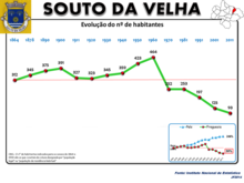
Souto da Velha was the seat of a municipality of the same name ( freguesia ) in the district ( concelho ) of Torre de Moncorvo in the Bragança district . The community had 93 inhabitants on an area of 12.45 km² (as of June 30, 2011).
With the territorial reform of September 29, 2013 , the municipalities of Souto da Velha and Felgar were merged to form the new municipality of União das Freguesias de Felgar e Souto da Velha . Felgar became the seat of the community.
traffic
Until the line was closed in 1988, Souto da Velha was connected to rail traffic with its own stop on the Linha do Sabor railway line .
Souto da Velha is about 6 km from the national road N220, which leads to the district town of Torre de Moncorvo, which is about 8 km away.
Web links
- Page to Souto da Velha at the Torre de Moncorvo district administration
- Entry to Souto da Velha in the Mapas de Portugal
- Private blog about Souto da Velha
Individual evidence
- ↑ Page on the town of Souto da Velha at the Torre de Moncorvo district administration, accessed on September 4, 2018
- ↑ www.ine.pt - indicator resident population by place of residence and sex; Decennial in the database of the Instituto Nacional de Estatística
- ^ Publication of the administrative reorganization in the Diário da República gazette of January 28, 2013, accessed on October 1, 2014


