Spencer Golf
| Spencer Golf Spencer Gulf |
||
|---|---|---|
| Waters | Great Australian Bay | |
| Land mass | Australia | |
| Geographical location | 34 ° 8 ′ S , 137 ° 4 ′ E | |
|
|
||
| width | 129 km | |
| depth | 322 km | |
|
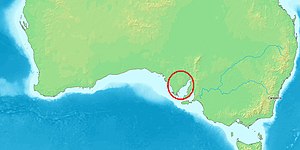
Location of the Gulf in Australia |
||
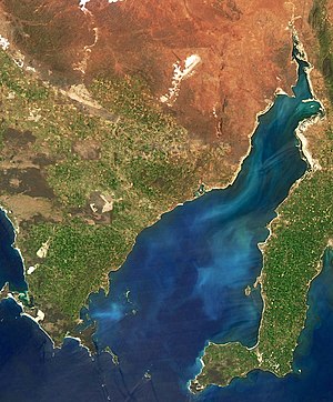
The Spencer Gulf or Spencer Gulf is the west of two large estuaries that extend into the south coast of Australia in the state of South Australia . Both are on the Great Australian Bight . The gulf is 322 km long and 129 km wide at the mouth. The west coast of the gulf is formed by the Eyre Peninsula , the east side by the Yorke Peninsula . The latter separates it from the smaller Gulf of Saint Vincent . The largest cities in the Gulf are Whyalla , Port Pirie and Port Augusta .
The Golf was by its discoverer Matthew Flinders in 1802 in honor of George Spencer, 2nd Earl Spencer , an ancestor of Diana of Wales , Spencer's Gulph called. Today the name "Spencer Gulf" is common. The arm of the sea was also baptized Golfe Bonaparte by Nicolas Baudin around the same time , but this designation could not establish itself (as in the case of the Fleurieu Peninsula, for example ).
The country around the Gulf was first explored for the Europeans in 1839 and 1840–41 by Edward John Eyre . Settlement of the coast began as early as the late 1840s.
Web links
Individual evidence
- ^ Matthew Flinders : A voyage to terra australis in the Years 1801-1803 . 2nd vol. With atlas, London 1814


