Springer height
| Springer height | ||
|---|---|---|
|
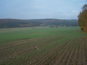
Northern edge of the Springer Höhe (left), behind it the Lange Rück at Frauensee |
||
| height | 371.6 m above sea level NN | |
| location | Thuringia ( Germany ) | |
| Coordinates | 50 ° 51 '52 " N , 10 ° 7' 1" E | |
|
|
||
| rock | Red sandstone | |
The fully wooded mountain Springer Höhe has a summit height of 371.6 m above sea level. NN and is part of the Frauenseer forest . It is located on the western edge of the Möllersgrund district , near the locality of Springen in the Wartburg district in Thuringia .
The side peaks, some of which are used for agriculture, also belong to the ridge
On the eastern flank of the mountain, in the Möllersgrund valley, the Frauensee district of the same name was created as a miners' settlement.
Individual evidence
- ↑ Official topographic maps of Thuringia 1: 10,000. Wartburgkreis, district of Gotha, district-free city of Eisenach . In: Thuringian Land Survey Office (Hrsg.): CD-ROM series Top10 . CD 2. Erfurt 1999.

