St. George Island (Florida)
| St. George Island | ||
|---|---|---|
| Beach on St. George Island | ||
| Waters | Gulf of Mexico | |
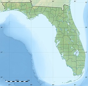
| Geographical location | 29 ° 39 ′ N , 84 ° 53 ′ W | |
|
|
||
| length | 48 km | |
| width | 1.6 km | |
| Highest elevation | 3.6 m | |
| Residents | 360 | |
| Bryant G. Patton Bridge from Eastpoint to St. George Island | ||
St. George Island is an island off the Gulf coast of the US state Florida . It is part of Franklin County and has approximately 360 permanent residents.
geography
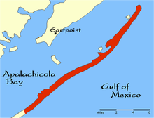
The elongated barrier island separates Apalachicola Bay from the Gulf of Mexico . To the west, only separated by the artificial canal known as the Government Cut , joins the uninhabited Little George Island , which is also called Cape St. George Island . The islands are 48 km long, only 400 to 1600 m wide and a maximum of 3.6 m high. St. George Island is accessible by car from US Highway 98 from Eastpoint via the seven-kilometer Bryant G. Patton Bridge . The coast to the Gulf of Mexico consists of miles of sandy beaches.
The barrier island shields the mainland behind it from hurricanes and tropical storms. The island has often been devastated by storms, each storm has changed the shape of the island.
history
The island was formed about 5000 years ago. Between the 10th and 15th centuries, Muskogee were the island's first known residents. Mounds of mussel shells also contained ceramic remains and evidence that the Indians collected oysters and other seafood. At the end of the 18th century, European colonists tried to colonize the island. In 1803, the Muskogee ceded a part of their land called Forbes Grant , including St. George Island, to the dealer John Forbes . During World War II the island for the troops on the road to served Carrabelle nearby Camp Gordon Johnson as a practice area. In 1954, the "Government Cut" or "Bob Sikes Cut" channel was built as a shipping route to Apalachicola Bay, which separates Little St. George Island from the main island. In 1965 the bridge to the mainland was completed. This made the island more accessible for tourists and a holiday destination.
The island received the status of a census-designated place on February 8, 2012 and in 2013 had 706 inhabitants.
Economy and sights
In the middle of the island is the small business center with restaurants and shops and an airport. There are numerous holiday homes on the island. In the east of the island is the Dr. Julian G. Bruce St. George Island State Park . The shallow Apalachicola Bay is an important oyster farming and fishing area. Until the middle of the 20th century, the island's Elliot pine forests were cut to produce resin. The escaping resin was collected and used to make turpentine. On older trees, the scars, known as the “cat face” caused by tapping, are still visible.
After a first lighthouse , built in 1833 and called Cape St. George Light , in the west of the island was destroyed by storms in 1846 and its successor, built in 1848, was destroyed by a hurricane in 1851, a third lighthouse was built in 1852. On September 10, 1974, the tower was entered on the National Register of Historic Places . In October 2005 this tower was also destroyed by a hurricane and was reconstructed from salvaged material and according to old plans by 2008. The lighthouse now serves as a museum.
environment
St. George Island is considered an environmentally friendly island. The state of Florida acquired the island's shores facing the bay and all of Little St. George Island. Together with St. George Island State Park, almost a third of the island's area is publicly owned. There are maximum sizes and heights for buildings, and building guidelines should protect the island from urban sprawl.
Web links
- Franklin County's Tourism Site
- Tourist information about St. George Island
- St. George Island, Florida in the Geographic Names Information System of the United States Geological Survey
Individual evidence
- ↑ Jay Barnes: Florida's Hurricane History. Chapel Hill: University of North Carolina Pr., 2007, p. 207
- ↑ St. George Island Information. (No longer available online.) Archived from the original on August 28, 2011 ; Retrieved August 10, 2011 . Info: The archive link was inserted automatically and has not yet been checked. Please check the original and archive link according to the instructions and then remove this notice.
- ↑ Kevin M. McCarthy: Apalachicola Bay. Sarasota: Pineapple Pr., 2004, ISBN 1-56164-299-1 , p. 16
- ↑ Feature Query Results. Geographic Names Information System , accessed July 16, 2015 .
- ↑ About SGPOA Airport (F47). (No longer available online.) Archived from the original on June 22, 2010 ; Retrieved August 10, 2011 . Info: The archive link was inserted automatically and has not yet been checked. Please check the original and archive link according to the instructions and then remove this notice.
- ^ FLORIDA - Franklin County. National Register of Historic Places , accessed July 27, 2015 .
- ^ St. George Lighthouse Association. Retrieved August 10, 2011 .


