St Mary's Hole
| St Mary's Hole | ||
|---|---|---|

|
||
| Geographical location | Scottish Borders , Scotland | |
| Tributaries | Megget Water from Megget Reservoir , Loch of the Lowes | |
| Drain | Yarrow Water → Ettrick Water → Tweed | |
| Data | ||
| Coordinates | 55 ° 29 '30 " N , 3 ° 11' 34" W | |
|
|
||
| length | 5 km | |
| width | 0.8 | |
| Maximum depth | 47 m | |
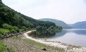
St Mary's Loch is a freshwater lake in the Scottish Lowlands. The lake is located in the Council Area Scottish Borders between the towns of Selkirk and Moffat about 72 km south of Edinburgh .
St Mary's Loch is curved into a sickle shape and has the typical elongated shape of a lake created by glaciers in the Ice Age . It is about five kilometers long, but only a maximum of 800 m wide. The lake receives water from numerous rivers and streams. The largest of these are Megget Water , which feeds St Mary's Loch in the west with water from the Megget Reservoir , and the only 150 m long tributary from the Loch of the Lowes immediately to the southwest . Other tributaries include Summerhope Burn , March Sike , Bowerhope Burn , Brocklie Sike , Kirkstead Burn, and Willies Grain . To the northwest, St Mary's Loch drains into the River Yarrow Water , of which it is the source.
St Mary's Loch is easily accessible from both Selkirk and Moffat via the well-developed A708. The lake is particularly popular with anglers. The main catches are trout . At the southern end of the lake there is a memorial to the Scottish writer James Hogg , in whose poetry the lake was included. Poems about St Mary's Hole also exist by William Wordsworth and Sir Walter Scott .
