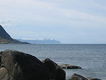
Stadlandet
Stadlandet , also Stadland ( -et is the Norwegian neuter article ) as well as Stad , Statt or Stadt for short , is a peninsula between the sea bays Sildegap in the west and Vanylvsfjord in the east and administratively belongs to the Norwegian municipality of Stad .
The peninsula is the northwesternmost part of the province ( Fylke ) Vestland . The outermost headland in the northwest of the peninsula is called Kjerringa and has also been called "Vestkapp" since the 1980s to attract tourists. It represents the closest point on the European mainland to Iceland . The westernmost point of Norway, however, is Vardetangen in the municipality of Austrheim .
Ship tunnel planning
The area of the North Sea around Stadlandet is known to have one of the harshest weather along the Norwegian coast. The sea in front of Stad, Stadhavet , is a fairway with demanding wave conditions on 90 to 110 days a year and dangerous cross lakes . Because of the frequent ship accidents off the peninsula, the construction of a ship tunnel is being planned. This Stad Skipstunnel is intended to cross the Stad peninsula at its narrowest point, the approximately 1.7 km wide isthmus between the Moldefjord in the west and the Vanylvsfjord in the east. In order for larger ships, such as those on the Hurtigruten , to be able to pass, the tunnel should have a cross-section height of 49 meters and a width of 36 meters, the fairway should be 26.5 meters wide and 12 meters deep and the maximum clearance height 37 meters. Construction is scheduled to start in 2020, and the first ships should be able to pass through four years later. The cost of this project has so far been estimated at 2.7 billion Norwegian kroner . The Norwegian government approved the project in April 2017.
History
There are many remains of German buildings from the Second World War in the area . The fortifications were mainly built by prisoners of war from Eastern Europe and the Soviet Union .
Ervik is located south of Kjerringa . Not far from the village, on September 30, 1943, the Hurtigruten passenger ship Sanct Svithun was set on fire by Canadian fighter bombers and then put aground by the crew on the cliffs near Ervik. Some of the residents tried to rescue survivors by boat. The ship's bell from Sanct Svithun hangs today in the Ervik chapel.
Web links
Individual evidence
- ↑ Project leather Randi Paulsen Humborstad, Nordfjord Vekst: Stad skipstunnel. Dimensjoner Stad Skipstunnel. In: project website. Retrieved August 27, 2018 (Norwegian).
- ↑ spiegel.de April 6, 2017
- ↑ www.kystverket.no April 5, 2017: NTP 2018–2029: Historisk satsing på sjøtransport
Coordinates: 62 ° 6 ' N , 5 ° 18' E

