
Sildegap
| Sildegap | ||
|---|---|---|
 Sildegap (view from Vågsøy to the northeast towards Stadlandet) |
||
| Waters | European Arctic Ocean | |
| Land mass | Scandinavian peninsula | |
| Geographical location | 62 ° 3 ' N , 5 ° 12' E | |
|
||
| length | 17 km | |

The Sildegap (Norwegian: Sildegapet ) is a large bay on the west coast of Norway in the province of Vestland .
The bay is located between the peninsula Stadlandet the north and the large island Vågsøya the south and belongs administratively to the north to the municipality city and south to the commune chin . It is 10 km wide at its opening to the European Arctic Ocean between the Kråkenes lighthouse in the northwest of the island Vågsøya and the Furenes headland on the southwest side of Stadlandet and extends about 17 km to the southeast, where it divides into three smaller fjords - the Moldefjord , the North Pollen and Sørpollen - and Ulvesund between Vågsøya and the mainland.
In the interior of the bay there are four larger, inhabited islands: in the west Silda , after which the bay is named, in the east Selja with the ruins of the monastery Selje , and in the south Barmøya and Venøya. Vågsøya and Venøya are connected to the mainland by bridges . The parts or foothills of the bay running around these islands are the Skorbøfjord in the north and the Hovsund in the southeast between Selja and Stadlandet, the Røysetfjord between Selja and Barmøya, the Barmsund between Barmøya and the mainland in the south and finally the Storpollen between Barmøya and Venøya or from north pollen to Ulvesund.
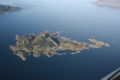
The island of Silda, view from the east; the Sildegap behind it
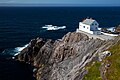
Kråkenes beacon at the entrance to the bay

Selja island, view from the east

Ruins of the Selje monastery
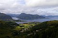
Barmøya island, view from the northeast (Røysetfjord on the right and Barmsund on the left); on the right in the background the island of Silda


Web links
- Sildegapet in the store norske leksikon (Norwegian)