Kråkenes fyr
| Kråkenes fyr | ||
|---|---|---|
| Kråkenes fyr | ||
| Place: |
|
|
| Location: | Northwest Cape of the Island | |
| Geographical location: | 62 ° 1 '15 " N , 4 ° 35' 29" E | |
| Height of tower base: | 36 moh. | |
| Fire carrier height : | 10.5 | |
| Fire height : | 42.2 | |
|
|
||
| Identifier : | Oc.WRG.6s | |
| Scope knows: | 12.8 nm (23.7 km ) | |
| Scope green: | 9.7 nm (18 km ) | |
| Scope red: | 10.2 nm (18.9 km ) | |
| Function: | Coastal fire | |
| Construction time: | 1950 | |
| Operating time: | since 1950 | |
| International ordinal number: | L0504 | |
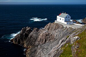
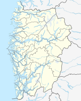
Kråkenes Fyr (nynorsk: Kråkenes fyrstasjon ) is a lighthouse on the island of Vågsøya in the Norwegian province of Vestland .
The first lighthouse was built in 1906 on the northwestern cape of the island. It was destroyed by fire in 1945 after an Allied air raid and rebuilt in 1950. The station stands 42.5 m above sea level and consists of a wooden main house, the former caretaker's house, with the 10 m high lighthouse built on the lake side, a weather station and a sheltered storm house. The beacon was automated in 1986. It shines white, red and green, depending on the direction, flashes every 6 seconds and is visible from a distance of 12.8 nautical miles .
The facility is also used for tourism. In the main house there is a restaurant , a café , a souvenir shop and a bridal suite. The Sturmhaus has five double rooms and is open for overnight stays from March to October.
See also
Web links
- Specifications of the lighthouse on the Kystverket website
- The Kråkenes Fyr lighthouse. Retrieved October 2, 2014 .
- Kråkenes Fyrstasjon. Norsk fyrhistorisk forening, accessed July 2, 2020 (Norwegian).


