Røysetfjord
| Røysetfjord | ||
|---|---|---|
|
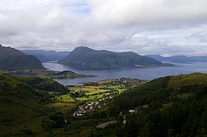
The island of Barmøya (center), the Røysetfjord (right in front of the island) and the Barmsund (left), the Salta peninsula (center left); View from the northeast |
||
| Waters | European Arctic Ocean | |
| Land mass | Scandinavian peninsula | |
| Geographical location | 62 ° 2 ′ 0 ″ N , 5 ° 18 ′ 0 ″ E | |
|
|
||
| length | 4.5 km | |
The Røysetfjord ( Norwegian Røysetfjorden ) is a sound and a south-eastern continuation of the large bay Sildegap on the west coast of Norway in Fylke Vestland . It is located in its entirety in the municipality of Stad and is named after the small town of Røyset on the north shore of the island of Barmøya .
The Røysetfjord runs between the two islands of Selja in the northeast and Barmøya in the southwest over a length of about 4.5 km from northwest to southeast. At its narrowest point it is 2 km wide.
In the southeast, Moldeford joins from the small Salta peninsula to the southeast. Even before Salta, the Hovsund branches off to the north at Selje, the administrative center of the municipality; it runs between the Stadlandet peninsula and the island of Selja. There, too, the Barmsund branches off to the southwest between Barmoya and the mainland.

