Moldefjord (Selje)
| Moldefjord | ||
|---|---|---|
|
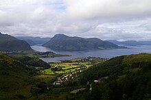
View over the Moldefjord to Selje and the island of Selja (top center) and Stadlandet (right and back) |
||
| Waters | European Arctic Ocean | |
| Land mass | Scandinavian peninsula | |
| Geographical location | 62 ° 1 '48 " N , 5 ° 22' 48" E | |
|
|
||
| length | 4.5 km | |
The Moldefjord ( Norwegian Moldefjorden ) is a southeastern branch of the large bay Sildegap on the west coast of Norway in the province of Vestland .
geography

The fjord is the south-eastern continuation of the Røysetfjord and is located in its entirety in the municipality of Stad in the extreme south-west of the Stadlandet peninsula . It begins in the north between the village of Selje and the small peninsula of Salta to the south, where the Saltnes beacon marks the entrance, and extends about 4.5 km to the southeast to the settlement of Berstad. On both banks there are almost continuously small hamlets and scattered settlements, and the provincial road Fv 618 runs along the entire length of the bank in the north, east and south.
Ship tunnel planning
Due to the often very difficult weather and sea conditions with dangerous cross seas off the Stadlandet peninsula, the construction of a ship tunnel , the Stad Skipstunnel, is being planned. This is supposed to cross under the isthmus, which is 1.7 km wide at its narrowest point, between the Moldefjord in the west and the Vanylvsfjord in the east. The tunnel will be around 1.7 kilometers long, 49 meters high and 36 meters wide, its fairway 12 meters deep and 26.5 meters wide and thus also enable Hurtigruten ships to pass through.
Web links
- www.stadskipstunnel.no (Norwegian)
- Moldefjorden in the store norske leksikon (Norwegian)


