
Selje

Selje was a municipality in the Nordfjord district in the northwest of the Norwegian province of Sogn og Fjordane (became part of Vestland in 2020 ). The administrative center was the village of the same name in the southwest. As part of the municipal reform in Norway , Selje, Eid and the eastern part of Vågsøy were merged to form the new municipality of Stad on January 1, 2020 .
2747 inhabitants lived in an area of 226 km² (as of January 1, 2019). The municipality number was 1441.
Geography and traffic
Selje was in the far northwest of Sogn og Fjordane on the peninsula Stadlandet and the offshore south of the peninsula in Røysetfjord Islands Selja , Barmøya and Venøya. The highest peaks in the municipality were the 645 m high Tarvalseffa northeast of the village Selje on Stadlandet and the 774 m high Kvamefjell on the mainland in the south. The municipality bordered Vanylven to the east and Vågsøy to the south .
Due to the often very difficult weather and sea conditions off the peninsula, the construction of a ship tunnel , the Stad Skipstunnel , is being planned, which will cross under the approximately 2 km wide isthmus between the Moldefjord in the southwest and the Vanylvsfjord in the northeast. An express boat runs daily between the boat harbor in Selje and Bergen .
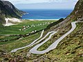
The villages and settlements in Selje were Årsheim, Barmen , Drage, Ervik, Flatraket, Hoddevik, Håvik, Kjøde, Leikanger , Otneim and Vetrhus. The many small settlements of the municipality were connected by four provincial roads: the Fv 618 in the south and west, the Fv 620 along the east coast and the Fv 632 and Fv 633 in the north of the peninsula.
history
The parish was named after the island of Selja, on which Sunniva von Selje , the patron saint of the Norwegian diocese of Bjørgvin and all of western Norway, is said to have died in the 10th century , on which the diocese of Selje was established in 1068 and moved to Bergen in 1170 was, and where in 1100 the Benedictines - Selje monastery was built, whose ruins can be seen there.
Dragseidet, a thing place, and Nidaros and Moster, a district of Bømlo between Haugesund and Bergen, are, according to tradition, the three places where King Olav Tryggvason enforced the Christianization of Norway at a thing meeting towards the end of the 10th century .
The municipality was founded on January 1, 1838 and at that time comprised the area of the historic parish Selje with the entire Stadlandet peninsula, the island Vågsøy further south and a section on the mainland north of the mouth of the Nordfjord . On January 1, 1910, the south-western part of the municipality was separated and formed into two independent municipalities, Nord-Vågsøy and Sør-Vågsøy. The northern area, previously called Hove, was now called Selje, with a population of 3,367 at that time. Another reclassification took place on January 1, 1964, when the municipalities of Nord-Vågsøy and Sør-Vågsøy were combined with a small part of Selje to form the new municipality of Vågsøy . Selje lost the island of Silda, west of Barmøya, and the northern part of the peninsula between Sørpollen and Ulvesund with the settlements Osmundsvåg and Hagevik in the north and east of the peninsula and the farms of Straumen and Sørpollen on the east and south banks of Sørpollen.
The municipality's coat of arms, approved in 1991, shows St. Sunniva , who died a martyr on the island of Selja.
economy
The local economy has traditionally been based on fishing and agriculture , and both continue to play important roles. Fish farming and boat building ( Saga Boats ) as well as services have also been added.
Personalities
- Claus Frimann (1746–1829), pastor and poet
Attractions

Ruins of the Selje monastery

Remains of the Sunniva church (front) and the Selje monastery (rear, with church tower)

Cave of St. Sunniva with the remains of the Mikaelskirche

Sandy beach and church of Selje on Stadlandet

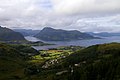
The Honningsvåg fjord
The village of Hoddevik

The Drage settlement

Årvik settlement

The Ervik Chapel

Selja island from the east
The island of Barmøya

The Moldefjord, the island of Selja (top center) and Stadlandet (right and back)


The most important sights in the municipality were on the island of Selja, about 15 minutes by motorboat across the 1000 m wide Hovsund west of the main town of Selje:
- the ruins of the Selje Monastery in the northwest
- the ruins of the Sunniva church near the monastery
- the cave of St. Sunniva with the remains of the Mikaelskirche, the first church on the island
- several Viking tombs and the remains of a longhouse from the Iron Age have been found in the south of the island.
In Ervik, at the northwest end of Stadlandet, there is a church dedicated to the memory of the Sanct Svithun dead; the ship was attacked on September 30, 1943 not far west of Ervik by fighter bombers of the Royal Canadian Air Force and then set burning on the cliffs of Kobbeholmen about 1.5 km northwest of Ervik. About 45 Norwegian civilians and twelve German soldiers lost their lives.
The 500 m long sandy beach at Ervik is suitable for surfing .
Footnotes
- ↑ Navn på nye kommuner. February 19, 2019, accessed January 11, 2020 (Norwegian).
- ↑ http://kirken.no/nn-NO/bispedommer/bjorgvin-bispedome/underliggjande-sider/sunniva-i-dag/?id=1354585
- ↑ Along with Oslo and Nidaros (Trondheim), Selje was one of the first three bishoprics in Norway.
- ↑ Dag Juvkam: Historisk oversikt over endringer i kommune- og fylkesinndelingen. Statistisk sentralbyrå - Statistics Norway, Oslo – Kongsvinger, 1999, ISBN 82-537-4684-9 ( Online , PDF)
Web links
- 1905 - The municipality of Selje (English)
- Selje, at gonorway.com (English)
- Independent wiki for the municipality of Selje
Coordinates: 62 ° 3 ′ 0 ″ N , 5 ° 24 ′ 0 ″ E