
City fortifications Pfaffenhofen an der Ilm

The late medieval fortification Pfaffenhofen was a 1.3-kilometer-long circular wall that formerly the almost twelve hectares large old town of Pfaffenhofen surrounded.
location
Little is left of the city fortifications. It ran (clockwise) along today's Riederweg , Stadtgraben , Schulstrasse , Kellerstrasse and Grabengasse . A city model that is placed on the main square near the former rent office shows the floor plan with the former city fortifications quite clearly. This was designed after the first map of Pfaffenhofen, in the Bavarian original cadastre from around 1810. The city wall as well as some gates and towers are still marked on this.
history
.jpg)
Pfaffenhofen is mentioned for the first time around the middle of the 12th century, even then the place was closely connected with the Wittelsbach family, to whom it owed its rise to a large extent and whose castle may have stood in the area of the "Hofberg". Under the protection of this castle, the settlement became increasingly important and was first referred to as a market at the end of the 12th century. Duke Ludwig den Kelheimer is believed to be the founder.
However, Pfaffenhofen only became a town in the legal sense in the 15th century. This is possibly related to the completion of the curtain wall, of which only a few remains have survived. Its construction is mentioned in 1437, without an express city elevation having preceded it.
To the south of the “Hofberg”, the layout of the buildings facing the Auengasse still reveals an original clustered village, while the two neighborhoods to the north of the main square suggest a planned layout. This expansion of the settlement is probably related to the reconstruction after the fire in 1388. After that, the rebuilt market settlement was raised to the status of a town because it had a closed wall.
Remnants of the city wall and towers
At Kellerstraße 5 ⊙ , Frauenstraße 34 ⊙ , Frauenstraße 36 ⊙ , Oberen Stadtmauer 17 ⊙ and Platzl 2 ⊙ there are still remnants of the former city fortifications. There are also remains of the brick wall along Grabengasse in the north and on the upper and lower city walls in the south. They probably date from the 15th century and were largely demolished in 1807. The underground remains of the city fortifications are protected as ground monuments , the structures that have been preserved as architectural monuments.
Remains of the city fortifications
- Remains of the brick wall along Grabengasse in the north and on the upper and lower city walls in the south have been preserved, 15th century, largely demolished in 1807
- Former city tower, so-called Pfänder tower, polygonal brick building with tent roof, 15th century
- Former city tower, three-storey, gable-independent steep saddle roof building with two-storey extension, upper storeys in stud frame construction, around 1500
- Former city tower "am Platzl"; property of electoral officials in the 17th and 18th centuries. They converted the tower into a summer house with a mansard roof.

Upper city wall 17, part of the city wall with a tower

Wall remains on the upper city wall

The "Stadtturm am Platzl" also called "Flaschlturm"
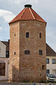
An isolated wall tower, the "Pfänder Tower", also known as the "Hunger Tower"


literature
- Documented local history of the city of Pfaffenhofen ad Ilm from 1857 by Joseph Heinrich Wolf (1803–1857), § 9 - Edited by Andreas Sauer, "Pfaffenhofener Stadtgeschichte (s)" No. 1, from December 2001.
- Heinrich Streidl, Franz Rutsch: 550 years of the city of Pfaffenhofen ad Ilm. 1998.
- City fortifications of Pfaffenhofen. In: Jolanda Drexler-Herold, Angelika Wegener-Hüssen: Landkreis Pfaffenhofen ad Ilm (= Bavarian State Office for Monument Preservation [Hrsg.]: Monuments in Bavaria . Volume I.19 ). Karl M. Lipp Verlag, Munich 1992, ISBN 3-87490-570-5 , p. 152 .
Individual evidence
- ↑ Bavaria. First recording of Pfaffenhofen an der Ilm, approx. 1810 in Bayernatlas Klassik
- ↑ LfD list for Pfaffenhofen an der Ilm (.pdf)
- ^ Website of the city of Pfaffenhofen: City tower on the upper city wall , accessed on September 17, 2018
- ↑ Upper city wall 17: City tower. In: Jolanda Drexler-Herold, Angelika Wegener-Hüssen: Landkreis Pfaffenhofen ad Ilm (= Bavarian State Office for Monument Preservation [Hrsg.]: Monuments in Bavaria . Volume I.19 ). Karl M. Lipp Verlag, Munich 1992, ISBN 3-87490-570-5 , p. 172 .
- ^ Website of the city of Pfaffenhofen: Flaschlturm , accessed on September 16, 2018
- ^ Platzl 2: City gate. In: Jolanda Drexler-Herold, Angelika Wegener-Hüssen: Landkreis Pfaffenhofen ad Ilm (= Bavarian State Office for Monument Preservation [Hrsg.]: Monuments in Bavaria . Volume I.19 ). Karl M. Lipp Verlag, Munich 1992, ISBN 3-87490-570-5 , p. 174 .
- ↑ Website of the city of Pfaffenhofen: Pfänder tower (hunger tower) , accessed on September 17, 2018
- ↑ Frauenstrasse 38: Pfänder tower. In: Jolanda Drexler-Herold, Angelika Wegener-Hüssen: Landkreis Pfaffenhofen ad Ilm (= Bavarian State Office for Monument Preservation [Hrsg.]: Monuments in Bavaria . Volume I.19 ). Karl M. Lipp Verlag, Munich 1992, ISBN 3-87490-570-5 , p. 162 .