Funiculaire du Pic du Jer
| Funiculaire de Pic du Jer funicular to the Pic du Jer |
|||||||||||||||||||||||||||||
|---|---|---|---|---|---|---|---|---|---|---|---|---|---|---|---|---|---|---|---|---|---|---|---|---|---|---|---|---|---|
| Route length: | 1,110 km | ||||||||||||||||||||||||||||
| Gauge : | 1000 mm ( meter gauge ) | ||||||||||||||||||||||||||||
| Top speed: | 11 km / h | ||||||||||||||||||||||||||||
|
|||||||||||||||||||||||||||||
The Funiculaire du Pic du Jer is a funicular railway that leads from the city of Lourdes to the Pic du Jer at an altitude of 889 meters.
history
As a result of the apparition of Mary in Lourdes in 1858, there was a steady stream of pilgrims visiting the place of pilgrimage. This gave the engineer Alphonse Chambrelent the idea of proposing to the city council of Lourdes the construction of a cable car to the summit of the Pic du Jer, in order to expand the religiously motivated tourism to a kind of nature tourism and to use the local mountain world. After a concession with a term of 75 years was obtained and the Compagnie du Funiculaire du Pic was founded, construction work began in August 1898 under the direction of the engineer Pierre Médebielle. The construction time was only about eight months and the most modern technology of the time was used. A material ropeway with a capacity of around 50 tons of rock, sand and wood per day was used to transport materials. Twice the normal amount of dynamite was used to blast cuts and galleries . The work went without major incidents and was completed in December 1899. After a short test phase, the cable car opened on June 16, 1900. After the Funiculaire du Capucin, it was the second cable car in France to be built for purely tourist purposes.
By 1953 the cable car had already carried 5 million visitors. Although the facility was operated all year round, the rush with up to 3000 people per day was greatest in the summer months. In 1954, renovations were necessary for the first time, especially in view of the expected rush for the centenary of the apparition of Mary. The drive motors of the cable winches were renewed and the wooden superstructures of the two cars were replaced with new ones made of all-metal construction. The work was completed in 1975. The founding company's license, which was extended as a result of the Second World War, expired in 1986 and the cable car became the property of the city of Lourdes. On January 25, 1996 the railway was handed over to a new operating company, the Société Pyrénéenne de Gestion, or Sopygest for short. The system was completely overhauled between 1995 and 1997, and also in 2004. On October 16, 2007, the operating company was liquidated and the cable car again went to the city of Lourdes. The plant is in operation from March to November and transports around 700,000 people annually.
Infrastructure
Transport links
The valley access to the cable car is on the outskirts of Lourdes, on the road to Cauterets . The Lourdes tram stopped near the facility until 1930 and the Lourdes-Pierrefitte-Nestalas branch line, which has now been closed, until 1975. Access to the platform consists of a wrought-iron gate from the construction period and a large parking lot for cars, coaches and public buses that connect the cable car to the city center.
Valley station
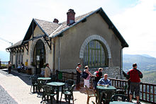
The valley station is located at a height of 415 meters and consists of a total of three buildings, all made of stone and with gable roofs . The two smaller ones house the station master and a power station , while the larger one houses the actual station. Inside the station building with the furnishings from the beginning of the 20th century, there is the ticket counter and several shops. On one of the inner walls there is a mural of the cave in the mountain, which can also be visited. The waiting room with the entrance is lit by four large windows.
Mountain station
The mountain station is located at 889 meters and consists of two buildings. The first is the entrance and the waiting room ... The second building, which is perpendicular to the railway, houses the engine room and shops. The route is 1110 meters long and overcomes a height difference of 473 meters in 15 minutes. The track runs in a single lane with a switch halfway, has a gauge of one meter , a length of twelve meters and a weight of 22 kilograms. The traction was carried out always electric. Originally it was fed by the power station in Lugagnan, and since 1935 by the one in Latour.
Technical
drive
During operation, the two cabins are firmly connected with a 32 millimeter thick wire rope, which is deflected in the upper station by means of a pulley. It was last renewed in 2007. The empty weights of both cabins roughly cancel each other out. The electric motor with an output of 136 kilowatts (185 hp) is designed for the case that a fully occupied cabin has to be lifted up and the other lowered empty. The top speed is eleven kilometers per hour.
dare
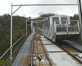
Originally the railway had wooden wagons that could hold a maximum of 50 passengers. The cars currently in use were built by Soulé in 1954 and were last technically overhauled in 1996. They weigh five tons and are each divided into five compartments with doors on either side. Each compartment can accommodate eight seated and eight standing passengers, for a total of 80 people per car. The associated driver's cab is located inside the passenger area.
Route
The journey begins in the valley with a 27 percent ascent , overcomes a short metal bridge and after a curve drives into a wooded area. This is followed by a straight section cut into the mountain on which the gradient increases to 39 percent and a first 75 meter long tunnel with a gradient of 43 percent. Next, the train reaches a 188-meter-long viaduct built entirely from granite and spanning nine arches with a radius of eight meters and two smaller ones with a radius of two and a half meters. The viaduct, on which there was originally a stop with a small snack bar, has an incline of 48 percent and carries the siding. After the viaduct, the slope increases steadily until it reaches 56 percent. The cable car then travels a further 400 meters straight through a 10 meter deep incision, passes through a 65 meter long tunnel and after a 40 meter short viaduct reaches the mountain station.
Web links
- Official website for the Funiculaire du Pic du Jer (English; also available in French and Spanish)
- Brief description and data sheet from the Association des funiculaires de France (French)
- Private website with detailed description and history (French)
Individual evidence
- ↑ a b c d e f g h i j k History and description of the Funiculaire du Pic du Jer. Retrieved September 5, 2013 .
- ↑ a b c d Data on the cable car. Retrieved September 5, 2013 .
- ↑ Funiculaire de Pic du Jer website , accessed on September 27, 2014.
Coordinates: 43 ° 4 ′ 56.3 " N , 0 ° 2 ′ 19.6" W.


