
Stanhope (Durham)
| coat of arms | map |
|---|---|
| none available | not available |
| Basic data | |
| country | Great Britain |
| Unitary Authority | County Durham |
| county | Durham |
| surface | ? km² |
| Residents | 4519 |
| Population density | ? |
| European region | Northern england |
| Height above M. | ? m |
| Post Code | DL12 |
Stanhope is the name of a market town in County Durham in northern England . It is located on the River Wear in Weardale . The A689 meets the B6278 from Barnard Castle to Shotley Bridge here .
The community Stanhope itself extends over a large area and includes both the places Rookhope, Westgate, St John's Chapel, Ireshopeburn, Wear Head, Cowshill, Cornriggs, Eastgate, Frosterley, all located on the A689, as well Crawleyside, Hill End and White Kirkley .
The area is very interesting for hikers, as the pastures for sheep have formed a heather landscape that is very attractive with streams running through it. The Pennines , in which Stanhope is located, are considered to be one of the most charming landscapes in England.
location
The main town Stanhope is in Weardale between Eastgate and Frorsterley. Next larger parishes are Newcastle upon Tyne , Bishop Auckland and Barnard Castle .
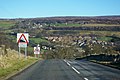
Stanhope town view

Heath at Stanhope

Ford at Stanhope
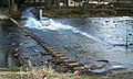
Ford at Stanhope
.jpg&filetimestamp=20070307071353&)


Attractions
- Stanhope: Stanhope Ford ( ford of Stanhope) through the river Wear , with extra stepping stones for pedestrians
- Stanhope: petrified tree stump in the courtyard of the church
- Stanhope: Durham Dales Center and Tea Room
Sons and daughters of the church
- Henry Horrocks Slater (* 1851), clergyman and naturalist
Web links
Coordinates: 54 ° 45 ′ N , 2 ° 1 ′ W