
Quarry in the Kothener Busch

The quarry in the Kothener Busch is a former quarry in the Kothener Busch forest in the Barmen district of the Bergisch city of Wuppertal . The Grauwackesteinbruch was due to the disrupted geological rock formations in accordance with § 22 a LG North Rhine-Westphalia as a "quarry - former Grauwackebruch -" for scientific, natural history, national heritage, or geological reasons as geological natural monument under protection. In terms of regional tectonics, the quarry is located on the northwest wing of the Remscheid-Altenaer saddle.
In the quarry the powerful mainly to north west were incident graywackes the mitteldevonischen Brandenberg layers degraded layers dead zone at the transition to the rich fossil. The impure sandstones , flat gray wackes alternate with gray slates and were deposited on a shelf in the Middle Devon , in the transition area from the land to the shallow sea.
The quarry is located on a slope facing the Wupper valley at a height of approx. 320 m on the southern edge of the Kothen residential area . In terms of its natural surroundings , the quarry with its rocks is part of the Lichtscheider Höhenrück ridge in the sense that it is also known regionally as the Wuppertaler Südhöhen .

Brick archway in the entrance to the quarry

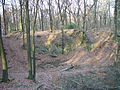
Detailed view of geological outcrop
Partial view

panorama

3D terrain model of the quarry


See also
Web links
Individual evidence
- ↑ § 22 a LG NRW
- ↑ technical information 2.6.2 of Landscape Plan East
- ^ Karl-Heinz Ribbert: Geology in the Rhenish Slate Mountains, Part 2 Bergisches Land , Krefeld 2012, ISBN 978-3-86029-935-7 , p. 46f.
- ↑ Alexander Fuchs, Werner Paeckelmann: Explanations of the geological map of Prussia and neighboring German countries, sheet Barmen No. 2721 , Preußische Geologische Landesanstalt (Ed.), Berlin 1928, p. 66f
Coordinates: 51 ° 15 ′ 9 ″ N , 7 ° 11 ′ 6.5 ″ E