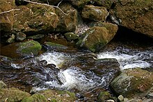
Steinklamm (Bavarian Forest)
The Steinklamm is a narrow valley south of Spiegelau in the Bavarian Forest , through which the Große Ohe flows.
Formation of the Steinklamm
The stone gorge was created primarily due to the great difference in altitude that the water in this area had to remove over a relatively short distance. At the end of the last Ice Age , the erosion was particularly intense here , due to the large amounts of meltwater flowing away. In the up to 100 m deep gorge , the various forms of erosion, for example smoothing, flow channels and the up to 2 m deep, predominantly sediment- filled whirlpool holes testify to the erosion power of the water.
history
In 1868 the geologist Carl Wilhelm von Gümbel declared the Steinklamm to be one of the “most remarkable natural attractions” of the Bavarian Forest. In the 18th century, due to the enormous water power of the Große Ohe, industrial companies settled in the uppermost area of the Steinklamm. Sawmills, iron hammers and later a pulp and cardboard factory were built. Today the Spiegelau sewage treatment plant is located in this area . Since the construction of a water weir, from which a considerable part of the Große Ohe is routed to generate electricity through a mountain tunnel and then in a canal bed to the Großarmschlag reservoir, significantly less water than before has flowed through the stone gorge. A cast-iron memorial cross that commemorates the tragic death of 16-year-old Agnes Grüner from Neisse / Silesia on March 12, 1881 shows that it used to be dangerous there . Only in 2005, on the private initiative of Fridolin Apfelbacher and his helpers, in cooperation with the community of Spiegelau and the city of Grafenau, today's hiking trail through the wild and romantic gorge was opened.
Flora
The Steinklamm home to a diverse flora: In the near-shore slope area of Maple Elm ravine forest with dominant sycamore maple (Acer pseudoplatanus) and elm (Ulmus montana). This ravine forest is partially closely interlinked with the black alder fringe that accompanies the stream. A spruce-beech-fir mixed forest, also called mountain spruce forest, dominates the picture further up. Spruce (Picea abies), European beech (Fagus sylvatica) and silver fir (Abies alba) give this forest type, which is most widespread in the middle altitudes of the Bavarian Forest. Blueberry bushes (Vaccinium myrtillus) and buckthorn bushes (Frangula alnus) grow next to each other, other typical bushes are deer elder (Sambucus racemosa), hazelnut (Corylus avellana), mountain ash (Sorbus aucuparia), sparrow bush (Spiraea salicifolia) and sea cattle. In the higher mountain spruce forest of the Steinklamm there are wood anemones (Anemone nemorosa), shadow flowers (Maianthemum bifolium), wood sorrel (Oxalis acetosella), white butterbur (Petasites albus), wood ziest (Stachys sylvatica), wood widow flower (Callosamigesagrostoliais) , Forest equestrian grass (Calamagrostis arundinacea) and single berry (Paris quadrifolia). The mountain soldanella (Soldanella montana), the forest grove (Luzula sylvatica) and the rare pine-bear moss (Huperzia selago) are botanical specialties. Numerous ferns are represented, including a. Worm fern (Dryopteris filixmas), beech fern (Phegopteris connectilis), oak fern (Gymnocarpium dryopteris). Thick cushions of moss cover rocks in the gorge.
rocks
The predominant rock is a cordierite-sillimanite-gneiss, which is a dark layered gneiss with light, lenticular quartz-feldspar aggregates. In addition, fine-grained, very tough calcium silicate rock with splintery fracture and light-gray, small to medium-grain, finely striped orthogneiss is exposed. These rocks were formed under high temperatures and high pressure deep in the earth's crust. Over 300 million years ago during the last mountain formation they were unfolded and finally came to the surface through erosion of the former high mountains. Tectonic faults led to the height differences that exist in the landscape today. Accordingly, the noticeable change in direction of the Große Ohe in the Steinklamm follows such a disturbance.
Hiking trail through the gorge
Several hiking routes in the area around the Steinklamm lead through the Klammweg. They are well marked with icons such as ladybugs and stone trout. In several places there are picture / text panels that offer very detailed information about the Steinklamm and its surroundings. The way through the gorge requires good footwear and surefootedness. It is not suitable for prams, bicycles and wheelchairs.
Hiking opportunities
- From the outdoor pool car park in Spiegelau via the town of Marienhöhe to shortly before Langdorf. From there to the Steinklamm, then up the gorge past the weir back to the parking lot. 5 km, 150 m difference in altitude.
- From the Spiegelau car park through the Steinklamm down the gorge over the Großarmschlag reservoir along the canal dam back to Spiegelau. 7 km, 150 m difference in altitude.
opening hours
The gorge is accessible from May to October.
literature
- "Bavarian Forest: Donautal - Regensburg - Passau" by Gernot Messarius, Verlag Friedrich Pustet, Regensburg (paperback - July 22, 2009)
- "ADAC hiking guide Bavarian Forest: Regensburg, Cham, Furth im Wald, Bayerisch Eisenstein, Grafenau Passau", ADAC Verlag (paperback - August 25, 2008)
- "With Apfelbacher into the Steinklamm", Passauer Neue Presse (edition of June 30, 2008, p. 28)
Web links
- Information tourism marketing Bavarian Forest over the gorge
- Description of the gorge by the Ostbayern eV tourism association
Coordinates: 48 ° 54 ′ 20.3 " N , 13 ° 21 ′ 40.5" E


