
Steinwedeler pond
| Steinwedeler pond | ||
|---|---|---|

|
||
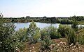
| Steinwedeler pond seen from the southeast, August 2009 | ||
| Geographical location | Steinwedel , Lehrte , Lower Saxony | |
| Islands | 1 | |
| Location close to the shore | Hanover | |
| Data | ||
| Coordinates | 52 ° 24 ′ 1 ″ N , 10 ° 0 ′ 0 ″ E | |
|
||
| Altitude above sea level | 59 m | |
| surface | 11.3 ha | |
| length | 400 m | |
| width | 320 m | |
| scope | 1.351 km | |
| Maximum depth | 9 m | |
| Middle deep | 5 m | |
|
particularities |
||

The stone Wedeler pond is a Stretch southeast of Steinwedel at Taught in the Region Hannover , Niedersachsen .
description
To the south and east of Steinwedel there are several gravel pits , some of which have been renatured. The largest of these lakes, with an area of around 11 hectares, was created around 1985, it is located immediately to the west of the road leading to the south and is known as Steinwedeler Teich.
The 10th degree of longitude runs right through the lake, 0.7 km south of Steinwedel .
A peninsula in the north and an island in the south are under nature protection and may not be entered. The water depth is mostly about 7 m, south of the island in the south only 2-3 m, in the northwest area at one point up to 9 m.
The lake is used by the Hanover fishing association as a fishing spot. It is considered difficult to fish. In 2009 eel, brown trout, perch, pike, carp, rainbow trout, roach, tench, catfish and pikeperch were reported from the lake.
Pictures of other gravel pits near Steinwedel
Renatured gravel pit 0.5 km east of the Steinwedeler pond

Renatured gravel pit 2 km east of the Steinwedeler pond, August 2010

