
Stone fronds
|
Stone fronds
City Taught
|
||
|---|---|---|
 |
||
| Height : | 57 (54-62) m above sea level NHN | |
| Area : | 13.24 km² | |
| Residents : | 1799 (December 31, 2016) | |
| Population density : | 136 inhabitants / km² | |
| Incorporation : | March 1, 1974 | |
| Postal code : | 31275 | |
| Area code : | 05136 | |
Location of Steinwedel in Lower Saxony |
||
 Steinwedel in the urban area of Lehrte
|
||


Steinwedel is a district of the city of Lehrte in the Hanover region in Lower Saxony (Germany).
geography
Geographical location
Steinwedel is located 13 km northeast of the state capital Hanover and 5 km north of Lehrte.
Neighboring places
The neighboring towns are Burgdorf in the north, Immensen in the east, Lehrte in the south, Aligse in the south-west and Röddensen in the west. The Burgdorfer Aue runs in the southwest . To the southeast of Steinwedel are the Steinwedeler Pond and others, e.g. T. renatured gravel pits .
history
The first documentary mention was made as "Stenwede" in a diocesan and Gau border description in 1022 , according to another source in 1299 .
The part of the name -wedel stands for a ford in the north of Germany .
Until 1974 Steinwedel was part of the Burgdorf district . On March 1, 1974, Steinwedel was incorporated into the city of Lehrte.
politics
Local council
The local council of Steinwedel consists of a councilwoman and four councilors from the following parties:
(Status: local election September 11, 2016)
Local mayor
The local mayor of Steinwedel is Jens Utermann (SPD). His deputy is Ralf Wengorsch (CDU).
coat of arms
The design of the coat of arms of Steinwedel comes from the heraldist and graphic artist Alfred Brecht , who created all coats of arms in the Hanover region. The approval of the coat of arms was granted on May 25, 1965 by the district president in Lüneburg.
|
|
Blazon : "In gold in the shield main three red iron hats , including a slight left at the sign foot lying, green branch with front right above one and below left two truncated branches a pile as growing , green acorn with two accompanying green oak leaves ." |
| Founding of the coat of arms: The municipality of Steinwedel has adopted the three red iron hats from the coat of arms of the noble lords "von Depenau". The famous Depenauer Mühle still reminds of this family today. The oak leaves with the acorn are supposed to keep the memory of the Steinwedeler Forest alive, which once covered almost the entire southern part of the Burgdorf district and in places also extended far into the neighboring districts. The branch in the base of the shield, which is modeled on a wolf tang, is intended to symbolize membership of the Burgdorf district , which has the wolf tang itself in its coat of arms. |
Culture and sights
Buildings
- In the Allegorical Garden , around 80 species of plants grow in thematic beds. Wild and cultivated plants, perennials and summer flowers, medicinal herbs and roses convey a unique garden image. The garden is reminiscent of an old Protestant preaching tradition.
- The current nave of the St. Petri Church was built in 1751; the tower dates from 1414. The Zuberbier organ was built in 1769 and redesigned in 1979.
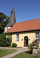
St. Peter's Church

Orientation board


Architectural monuments
→ See: List of architectural monuments in Steinwedel
societies
Sports, mainly handball and popular sports, take place primarily at TSV Steinwedel .
Economy and Infrastructure

Steinwedel is characterized by agriculture. There is also a bamboo nursery and some smaller businesses. The majority of the population finds employment outside of the town.
A bus line operated by Greater Hanover connects Steinwedel with Lehrte and Burgdorf.
literature
- Anette Lienert: Steinwedel - From the history of a village . Stadtverwaltung Lehrte (Ed.), (= Stadtgeschichtlichehefte der Stadt Lehrte, Volume 10), Lehrte 1994.
- Ursula Gerstenberg: village, house and farm stories, Steinwedel . Kultur-Kontor, Peine.
- Otto Grethe: Steinwedeler story . 2011.
- Otto Grethe: The Steinwedeler farms and their old farm names .
Web links
- www.steinwedel-info.de - Everything about Steinwedel
- www.heimatverein-steinwedel.de - Heimatverein Steinwedel
Individual evidence
- ↑ a b Population and area areas. In: Website of the city of Lehrte. Retrieved May 16, 2019 .
- ↑ Information about Steinwedel. In: www.steinwedel-info.de. Retrieved October 10, 2017.
- ↑ Orientation board . In: Wikimedia Commons. Retrieved October 10, 2017.
- ↑ Anette Lienert: Steinwedel - From the history of a village . Stadtverwaltung Lehrte (Ed.), (= Stadtgeschichtlichehefte der Stadt Lehrte, Volume 10), Lehrte 1994.
- ^ Federal Statistical Office (ed.): Historical municipality directory for the Federal Republic of Germany. Name, border and key number changes in municipalities, counties and administrative districts from May 27, 1970 to December 31, 1982 . W. Kohlhammer, Stuttgart / Mainz 1983, ISBN 3-17-003263-1 , p. 222 .
- ↑ a b List of local councilor Steinwedel. In: Website of the city of Lehrte. Retrieved August 26, 2017.
- ^ A b Landkreis Hannover (ed.): Wappenbuch Landkreis Hannover . Self-published, Hanover 1985, p. 262-269 .
- ↑ Allegorical Garden In: Ev.-luth. Parish of St. Petri Steinwedel. Retrieved May 16, 2019.
Ahlten | Aligse | Arpke | Hämelerwald | Immense | Kolshorn | Taught | Röddensen | Sievershausen | Stone fronds